USGS - science for a changing world

Upper Midwest Environmental Sciences Center

Home/ Overview/ Science Programs/ Data Library/ Products and Publications/States/ Rivers/Teachers and Students/ Links/ Contact/ Search

Select a River

This path will lead you to information, data and project status categorized by river.

Upper Mississippi Upper Mississippi River (map)
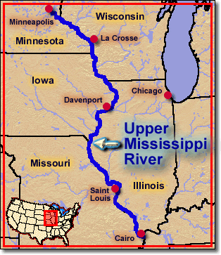
Select a Reach - Upper Mississippi River
  • Reach 1 - Navigation Pools 1 through 13
  • Reach 2 - Navigation Pools 14 through 26
  • Reach 3 - Lock and Dam 26 to the confluence with the Ohio River

UMESC Projects - Complete listing of UMESC projects conducted along the Upper Mississippi River.

Illinois
Select a Reach - Illinois River
  • Alton - Mississippi River to the La Grange lock and dam.
  • Brandon - The Brandon lock and dam to the Lockport lock and dam.
  • Dresden - The Dresden lock and dam to the Brandon lock and dam.
  • La Grange - The La Grange lock and dam to the Peoria lock and dam.
  • Lockport - The Lockport lock and dam to Lake Michigan.
  • Marseilles - The Marseilles lock and dam to the Dresden lock and dam.
  • Peoria - The Peoria lock and dam to the Starved Rock lock and dam.
  • Starved Rock - The Starved Rock lock and dam to the Marseilles lock and dam.
Saint Croix


Accessibility FOIA Privacy Policies and Notices

Take Pride in America logo USA.gov logo U.S. Department of the Interior | U.S. Geological Survey
URL: http://www.umesc.usgs.gov/rivers.html
Page Contact Information: Contacting the Upper Midwest Environmental Sciences Center
Page Last Modified: October 2, 2007