California Water Science Center Site Locations
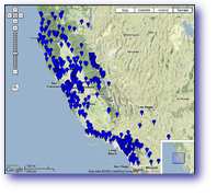
Real-Time Ground-water SitesReal-time sites - Current-conditions data transmitted from selected ground-water sites. Values in pop-up bubbles are updated hourly. Additional data for real-time sites. Field water-level measurements - Manual measurements of depth to water in wells. These measurements are often used to supplement and (or) verify the accuracy of the instantaneous measurements. Selected sites with at least 10 measurements are included in these maps. The last value available is shown in the pop-up bubble for each site. Because of the large number of sites available the sites have been broken up into three regions. All of California is available but not recommended for slower internet connections. Addtional data for ground-water sites. You may also be interested in multi-depth water-level measurements - Links to current-condition data and manual measurements of depth to water in multi-depth wells. Photo, site descriptions and additional information is available from the pop-up bubbles for sites included in this map. Data are provisional and subject to revision. Data Portals |

![]() U.S. Department of the Interior |
U.S. Geological Survey
U.S. Department of the Interior |
U.S. Geological Survey
URL: http://ca.water.usgs.gov/gmaps/gw_rt_map.html
Page Contact Information: GS-W-CAdist WWW
Page Last Modified: Tuesday, 22-Jul-2008 17:00:41 EDT