
Volcano Information
-
Glacier Peak
- Status: Glacier Peak is monitored by the Cascade Volcano Observatory and is at a background level of activity.
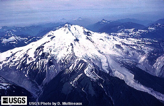 Volcanic History Overview: Glacier Peak, the most isolated of the Cascade volcanoes, rises to 3213 m above the rugged forested terrain of the Glacier Peak Wilderness Area in the North Cascades. Glacier Peak is a dacitic-andesitic stratovolcano with summit and flank lava domes; it resembles Mount St. Helens in its explosive vigor. More than a dozen glaciers descend its flanks, prompting its name. Although its summit towers 3000 m above surrounding valleys, the volcano was constructed above a high ridge and is itself less than 1000 m high. Repeated major explosive eruptions associated with lava dome growth during the late Pleistocene and Holocene deposited tephra over wide distances to the east. Voluminous pyroclastic flows and mudflows extended into the Puget Sound lowlands to the west and diverted several river courses into adjacent valleys. The latest eruption of Glacier Peak only a few hundred years ago was noted by indigenous Pacific Northwest Indians, and hot springs occur on its flanks.
 Location: Western US, WA
Latitude: 48.112
Longitude: -121.113
Elevation: 3213 m
Recent Eruption: 300 years ago- Hazard Assessments: Waitt, et.al., 1995, Volcanic-Hazard Zonation for Glacier Peak Volcano, Washington, USGS Open-File Report 95-499.
- Link to monitoring data: The Pacific Northwest Seismic Network
Volcanic Alert Level: NORMAL Aviation Color Code: GREEN
