
 Feeds & Data
Magnitude 5.1 - FIJI REGION
2008 November 03 19:36:21 UTC
Earthquake Details
| Magnitude | 5.1 |
|---|---|
| Date-Time |
|
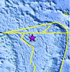
| Location | 16.286°S, 176.325°W |
| Depth | 370.1 km (230.0 miles) set by location program |
| Region | FIJI REGION |
| Distances | 280 km (170 miles) W of Hihifo, Tonga 295 km (185 miles) SE of Sigave, Ile Futuna, Wallis and Futuna 550 km (340 miles) NNW of NUKU'ALOFA, Tonga 2445 km (1520 miles) NNE of Auckland, New Zealand |
| Location Uncertainty | horizontal +/- 6.5 km (4.0 miles); depth fixed by location program |
| Parameters | NST=164, Nph=164, Dmin=620.2 km, Rmss=0.84 sec, Gp= 97°, M-type=body magnitude (Mb), Version=Q |
| Source |
|
| Event ID | us2008yyca |
- This event has been reviewed by a seismologist.
- Did you feel it? Report shaking and damage at your location. You can also view a map displaying accumulated data from your report and others.
Earthquake Summary

 Tsunami Information
- NOAA West Coast & Alaska Tsunami Warning Center
- NOAA Pacific Tsunami Warning Center
- Tsunami Information Links
The earthquake locations and magnitudes cited in these NOAA tsunami bulletins are very preliminary and may be superceded by USGS locations and magnitudes computed using more extensive data sets.
Earthquake Maps
Earthquake Location
Location Maps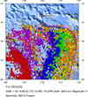
Historical Seismicity
Seismic Hazard Map
EQ Density Map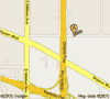
Google Map
Google Earth KML
(Requires Google Earth)- Did you feel it? Report shaking and damage at your location. You can also view a map displaying accumulated data from your report and others.
Scientific & Technical Information
 Historic Moment Tensor Solutions
- Preliminary Earthquake Report
- U.S. Geological Survey, National Earthquake Information Center:
World Data Center for Seismology, Denver
