
 Feeds & Data
Magnitude 4.7 - EAST OF THE KURIL ISLANDS
2008 November 02 02:36:02 UTC
Earthquake Details
| Magnitude | 4.7 |
|---|---|
| Date-Time |
|
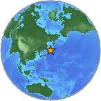
| Location | 44.963°N, 150.749°E |
| Depth | 39 km (24.2 miles) |
| Region | EAST OF THE KURIL ISLANDS |
| Distances | 230 km (140 miles) E of Kuril'sk, Kuril Islands 555 km (345 miles) ENE of Kushiro, Hokkaido, Japan 1395 km (860 miles) NE of TOKYO, Japan 7215 km (4480 miles) NE of MOSCOW, Russia |
| Location Uncertainty | horizontal +/- 11.9 km (7.4 miles); depth +/- 9.9 km (6.2 miles) |
| Parameters | NST= 58, Nph= 58, Dmin=655.5 km, Rmss=0.75 sec, Gp=176°, M-type=body magnitude (Mb), Version=Q |
| Source |
|
| Event ID | us2008yxal |
- This event has been reviewed by a seismologist.
- Did you feel it? Report shaking and damage at your location. You can also view a map displaying accumulated data from your report and others.
Earthquake Maps
Earthquake Location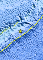
Location Maps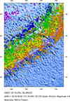
Historical Seismicity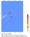
Seismic Hazard Map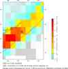
EQ Density Map
Google Map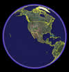
Google Earth KML
(Requires Google Earth)- Did you feel it? Report shaking and damage at your location. You can also view a map displaying accumulated data from your report and others.
Scientific & Technical Information
 Historic Moment Tensor Solutions
- Preliminary Earthquake Report
- U.S. Geological Survey, National Earthquake Information Center:
World Data Center for Seismology, Denver
