
 Feeds & Data
Magnitude 4.6 - SANTA CRUZ ISLANDS
2008 November 01 16:48:28 UTC
Earthquake Details
| Magnitude | 4.6 |
|---|---|
| Date-Time |
|
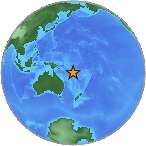
| Location | 12.577°S, 166.948°E |
| Depth | 216.9 km (134.8 miles) set by location program |
| Region | SANTA CRUZ ISLANDS |
| Distances | 240 km (150 miles) SSE of Lata, Santa Cruz Islands, Solomon Isl. 325 km (205 miles) N of Luganville, Espiritu Santo, Vanuatu 840 km (520 miles) ESE of HONIARA, Guadalcanal, Solomon Islands 2190 km (1360 miles) NE of BRISBANE, Queensland, Australia |
| Location Uncertainty | horizontal +/- 9 km (5.6 miles); depth fixed by location program |
| Parameters | NST= 61, Nph= 61, Dmin=840.5 km, Rmss=0.81 sec, Gp=122°, M-type=body magnitude (Mb), Version=Q |
| Source |
|
| Event ID | us2008ywb5 |
- This event has been reviewed by a seismologist.
- Did you feel it? Report shaking and damage at your location. You can also view a map displaying accumulated data from your report and others.
Earthquake Maps
Earthquake Location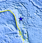
Location Maps
Historical Seismicity
Seismic Hazard Map
EQ Density Map
Google Map
Google Earth KML
(Requires Google Earth)- Did you feel it? Report shaking and damage at your location. You can also view a map displaying accumulated data from your report and others.
Scientific & Technical Information
 Historic Moment Tensor Solutions
- Preliminary Earthquake Report
- U.S. Geological Survey, National Earthquake Information Center:
World Data Center for Seismology, Denver
