
 Feeds & Data
Magnitude 4.9 - MARIANA ISLANDS REGION
2008 November 01 09:23:13 UTC
Earthquake Details
| Magnitude | 4.9 |
|---|---|
| Date-Time |
|
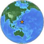
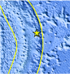
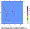
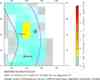
| Location | 18.446°N, 147.161°E |
| Depth | 60.3 km (37.5 miles) |
| Region | MARIANA ISLANDS REGION |
| Distances | 150 km (95 miles) ENE of Pagan, Northern Mariana Islands 160 km (100 miles) ESE of Agrihan, Northern Mariana Islands 390 km (240 miles) NNE of SAIPAN, Northern Mariana Islands 610 km (375 miles) NNE of HAGATNA, Guam |
| Location Uncertainty | horizontal +/- 28.2 km (17.5 miles); depth +/- 18.5 km (11.5 miles) |
| Parameters | NST= 17, Nph= 17, Dmin=590.9 km, Rmss=0.59 sec, Gp=220°, M-type=body magnitude (Mb), Version=Q |
| Source |
|
| Event ID | us2008ywa3 |
- This event has been reviewed by a seismologist.
- Did you feel it? Report shaking and damage at your location. You can also view a map displaying accumulated data from your report and others.
Earthquake Maps

Scientific & Technical Information
 Historic Moment Tensor Solutions
- Preliminary Earthquake Report
- U.S. Geological Survey, National Earthquake Information Center:
World Data Center for Seismology, Denver
