
 Feeds & Data
Magnitude 4.6 - MORO GULF, MINDANAO, PHILIPPINES
2008 October 30 05:47:33 UTC
Earthquake Details
| Magnitude | 4.6 |
|---|---|
| Date-Time |
|
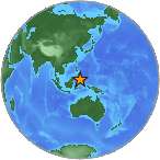
| Location | 6.737°N, 123.802°E |
| Depth | 568.4 km (353.2 miles) |
| Region | MORO GULF, MINDANAO, PHILIPPINES |
| Distances | 75 km (45 miles) SW of Cotabato, Mindanao, Philippines 125 km (80 miles) SSE of Pagadian, Mindanao, Philippines 165 km (105 miles) WNW of General Santos, Mindanao, Philippines 930 km (570 miles) SSE of MANILA, Philippines |
| Location Uncertainty | horizontal +/- 10.8 km (6.7 miles); depth +/- 20.9 km (13.0 miles) |
| Parameters | NST= 27, Nph= 27, Dmin=>999 km, Rmss=0.63 sec, Gp=101°, M-type=body magnitude (Mb), Version=Q |
| Source |
|
| Event ID | us2008yua9 |
- This event has been reviewed by a seismologist.
- Did you feel it? Report shaking and damage at your location. You can also view a map displaying accumulated data from your report and others.
Earthquake Maps
Earthquake Location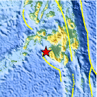
Location Maps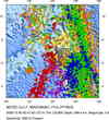
Historical Seismicity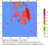
Seismic Hazard Map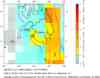
EQ Density Map
Google Map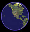
Google Earth KML
(Requires Google Earth)- Did you feel it? Report shaking and damage at your location. You can also view a map displaying accumulated data from your report and others.
Scientific & Technical Information
 Historic Moment Tensor Solutions
- Preliminary Earthquake Report
- U.S. Geological Survey, National Earthquake Information Center:
World Data Center for Seismology, Denver
