
 Feeds & Data
Magnitude 3.0 - PUERTO RICO REGION
2008 November 02 20:58:32 UTC
Earthquake Details
| Magnitude | 3.0 |
|---|---|
| Date-Time |
|
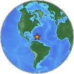
| Location | 19.529°N, 66.366°W |
| Depth | 41.2 km (25.6 miles) |
| Region | PUERTO RICO REGION |
| Distances |
|
| Location Uncertainty | horizontal +/- 4.2 km (2.6 miles); depth +/- 24.8 km (15.4 miles) |
| Parameters | Nph=019, Dmin=137.1 km, Rmss=0.4 sec, Gp=284°, M-type=duration magnitude (Md), Version=1 |
| Source | |
| Event ID | prp0830726 |
- This event has been reviewed by a seismologist.
- Did you feel it? Report shaking and damage at your location. You can also view a map displaying accumulated data from your report and others.
Earthquake Maps
Earthquake Location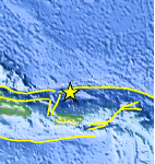
Location Maps
Historical Seismicity
Seismic Hazard Map
Google Map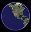
Google Earth KML
(Requires Google Earth)- Did you feel it? Report shaking and damage at your location. You can also view a map displaying accumulated data from your report and others.
Scientific & Technical Information
 Historic Moment Tensor Solutions
- Preliminary Earthquake Report
- Puerto Rico Seismic Network, University of Puerto Rico
