
 Feeds & Data
Magnitude 2.9 - UNIMAK ISLAND REGION, ALASKA
2008 November 04 15:02:08 UTC
Earthquake Details
| Magnitude | 2.9 |
|---|---|
| Date-Time |
|
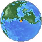
| Location | 54.460°N, 163.770°W |
| Depth | 98.7 km (61.3 miles) |
| Region | UNIMAK ISLAND REGION, ALASKA |
| Distances |
|
| Location Uncertainty | horizontal +/- 5.5 km (3.4 miles); depth +/- 0.5 km (0.3 miles) |
| Parameters | NST=012, Nph=012, Dmin=20.7 km, Rmss=1.34 sec, Gp=198°, M-type=local magnitude (ML), Version=1 |
| Source | |
| Event ID | ak00076262 |
- This is a computer-generated message -- this event has not yet been reviewed by a seismologist.
- Did you feel it? Report shaking and damage at your location. You can also view a map displaying accumulated data from your report and others.
Earthquake Maps
Earthquake Location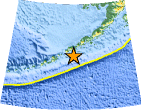
Location Maps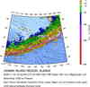
Historical Seismicity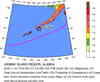
Seismic Hazard Map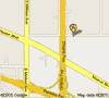
Google Map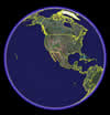
Google Earth KML
(Requires Google Earth)- Did you feel it? Report shaking and damage at your location. You can also view a map displaying accumulated data from your report and others.
Scientific & Technical Information
 Historic Moment Tensor Solutions
- Preliminary Earthquake Report
- Alaska Earthquake Information Center
Geophysical Institute, University of Alaska Fairbanks
