
 Feeds & Data
Magnitude 3.2 - SOUTHERN ALASKA
2008 November 01 22:58:59 UTC
Earthquake Details
| Magnitude | 3.2 |
|---|---|
| Date-Time |
|
| Location | 61.477°N, 149.927°W |
| Depth | 46.5 km (28.9 miles) set by location program |
| Region | SOUTHERN ALASKA |
| Distances |
|
| Location Uncertainty | Error estimate not available |
| Parameters | NST=042, Nph=052, Dmin=37 km, Rmss=0 sec, Gp= 54°, M-type=local magnitude (ML), Version=3 |
| Source | |
| Event ID | ak00075729 |
- This event has been reviewed by a seismologist.
- Did you feel it? Report shaking and damage at your location. You can also view a map displaying accumulated data from your report and others.
Earthquake Maps

Earthquake Location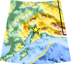
Location Maps
PAGER
Population Exposure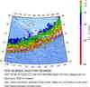
Historical Seismicity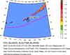
Seismic Hazard Map
Google Map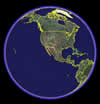
Google Earth KML
(Requires Google Earth)- Did you feel it? Report shaking and damage at your location. You can also view a map displaying accumulated data from your report and others.
Scientific & Technical Information
 Historic Moment Tensor Solutions
- Preliminary Earthquake Report
- Alaska Earthquake Information Center
Geophysical Institute, University of Alaska Fairbanks
