 Recent Earthquakes in Central US
Disclaimer
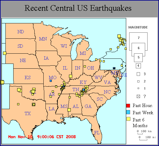
There are 193 earthquakes on this map.
Did you feel it? -
Please fill out a
felt report
(even if you didn't feel it).
For Other earthquakes:
USGS
Click on an earthquake on the above map for a zoomed-in view.
Special maps:
Not Implemented
Earthquake lists:
big earthquakes ||
all earthquakes
Magnitude = ? for new earthquakes until a magnitude is determined (takes 4-5 minutes).
Maps are updated within 1-5 minutes of an earthquake or once an hour.
(Smaller earthquakes are added after
human processing, which may take several hours.)
Map need updating? Try reloading the page to your browser.
Brown lines are known hazardous faults and fault zones.
Other Information:
How do earthquakes get on these maps? ||
FAQ's ||
Disclaimer
Earthquakes elsewhere in the U.S. and around the world
Top page ||
Other sites for eq info ||
Other earthquake sites ||
Credits
Data Sources:
Central U.S. - Cooperative Central and Southeast U.S. Seismic Network CERI/SLU/VPI/USC =
Center for Earthquake Research and Information
Southeast U.S. - Southeast U.S. Seismic Network =
Southeastern U.S. Seismic Networks
Northern California - USGS =
U.S. Geological Survey, Menlo Park
Northern California - UCB =
University of California, Berkeley
Southern California - USGS =
U.S. Geological Survey, Pasadena
Southern California - Caltech =
California Institute of Technology
Southern California - UCSD =
University of California, San Diego
Nevada - UNR =
University of Nevada, Reno
US and World - USGS/NEIC =
National Earthquake Information Center
Please email suggestions and comments to withers@ceri.memphis.edu