
Earthquake Research
 Borehole Geophysics and Rock Mechanics
Using borehole geophysical measurements in conjunction with laboratory studies, scientists study heat flow, stress, fluid pressure, and the mechanical behavior of fault-zone materials at seismogenic depths to yield improved models of the earthquake cycle.
 Crustal Deformation
Plate motion produces distortion or deformation in the surface of the earth near active faults. Several techniques are used to measure this deformation, including GPS, 2-color Electronic Distance Meters (EDMs), strain meters, magnetometers, tilt meters, and water level monitors.
 Earthquake Geology & Paleoseismology
Earthquake geology in the broad sense is the study of the history, effects, and mechanics of earthquakes within and on the Earth's crust.
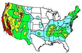 Earthquake Hazards
All of the research into where, how, when, and why earthquakes occur feeds into determination of the national seismic hazard maps. Scientists use the results of research in probability determinations for the National Seismic Hazards Map. Regional studies supplement the national maps.
 Regional & Whole-Earth Structure
Seismic waves from earthquakes, man-made sources both local and distant, computer generated simulations and geophysical surveys are used to determine local, crustal, mantle and core structures of the earth.
 Strong-motion Seismology, Site Response & Ground Motion
Strong motion seismology uses special sensors, called accelerometers, to record large-amplitude ground motions and the response of engineered structures to these motions.
