U.S. Geological Survey

South Florida Information Access - Virtual Tour

virtual tour home

Lake Okeechobee
Jonathan Dickinson SP
Blowing Rocks
Fern Forest
Controlling the Waters
Loxahatchee
West Lake/Anne Kolb
Alligator Alley
Big Cypress
Corkscrew Swamp
Fakahatchee
Biscayne NP
Everglades NP
Florida Bay/Keys
10,000 Islands/ Rookery Bay
- 10,000 Islands
- Rookery Bay
Ecosystems

Glossary
Photo Gallery
About this site

SOFIA Home

Ten Thousand Islands and Rookery Bay

| 10,000 Islands | Rookery Bay |

Map of Ten Thousand Islands and Rookery Bay
Map showing location of Ten Thousand Islands and Rookery Bay.
The Ten Thousand Islands are comprised of hundreds of mangrove islands that extend northward from the northwest corner of Everglades National Park. These uninhabited islands stretch for 60-miles along the Gulf Coast. Surrounding the Ten Thousand Islands is an estuary, formed from where freshwaters from the land meet with saltwater from the Gulf of Mexico.

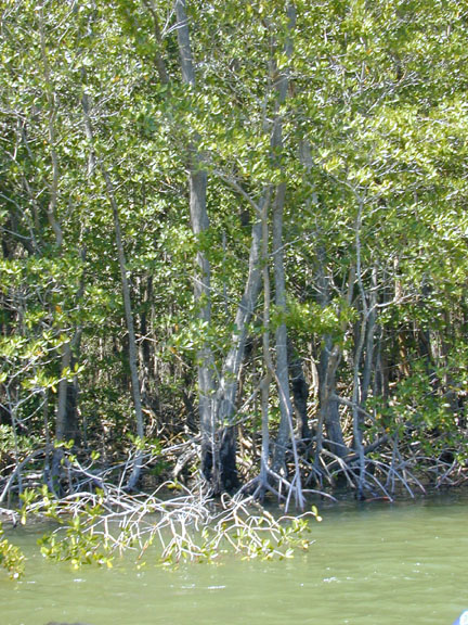
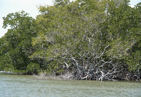
Mangrove forests are very important in this marine environment. Mangrove leaves, trunks and branches fall into the water and are transformed into detritus, which is the basis of an elaborate food chain. Mangroves provide protected habitat, breeding grounds and nursery areas to many terrestrial and marine animals. Mangroves also provide shoreline protection from wind, waves and floods.

Launch the boat from Everglades City and see some of the southern Ten Thousand Islands where the landscape is dominated by mangrove forests and water.

A photo gallery is available for this page.

Ten Thousand Islands
A sign posted in bay waters welcomes visitors to Everglades National Park. Some of the southern Ten Thousand Islands fall within Everglades National Park boundaries. photo of sign welcoming boaters to Everglades National Park
[larger image]
photo of mangrove tree islands and Chokoloskee Bay Looking northwest at Chokoloskee Bay waters and mangrove tree islands.
[larger image]
A beach along one of the Ten Thousand Islands.
[larger image]
photo of beach along a mangrove island
photo of Chokoloskee Bay and mangrove tree islands
[larger image]
Beyond the mangrove key islets that make up the Ten Thousand Islands, lies the Gulf of Mexico. Tannins produced by mangrove detritus cause for murky waters nearby the Ten Thousand Islands. The waters cleared and became greener as we traveled toward the open Gulf of Mexico.

photo of mangrove
[larger image]
A closer look at the mangrove trees that make up the Ten Thousand Islands. Mud, sands, oyster shells and organic debris get trapped between the roots of the mangroves, possibly causing the island to grow larger over time. photo of mangroves
[larger image]

photo of mangroves
[larger image]

photo of adult brown pelican
[larger image]
Pelicans
(Left) Adult brown pelican posing on a boat dock at Everglades City.

(Right) Adult brown pelicans and a second-year pelican swimming by a boat dock at Everglades City.

photo of pelicans in the water
[larger image]
Adult pelicans in summer plumage have a white head and a brown stripe on the back of the neck. Second-year pelicans are gray and do not have seasonal plumage. Adults have a dark belly while first- and second-year pelicans have a white belly.

Pelicans are large waterbirds and are commonly seen throughout Florida. Pelicans mainly eat fish.

Osprey
photo of osprey pair in their nest
[larger image]

An osprey parent and chick in their nest.

photo of osprey parent and chick in their nest
[larger image]

Ospreys are large, fish-eating, birds of prey. They are commonly confused with bald eagles because of their white heads. To aid in identification, look for the osprey's dark band across its face and the osprey's white belly.

Osprey pairs usually expand and repair the same nest year after year. Building nests atop the mangrove islands (as seen in these photos) provides the osprey and their young safety from predators and a close supply of fish.

photo of osprey family in their nest
[larger image]

An osprey family in their nest.

photo of osprey parent and chick in their nest
[larger image]

Female osprey incubates the eggs with occasional help from the male. Once the eggs hatch, the male does all the fishing for about 6 weeks, after which both parents fish to feed the young chicks. Chicks leave the nest about 8 weeks after hatching.

Immature Bald Eagle
photo of immature bald eagle
An immature bald eagle along the Chokoloskee Bay. [larger image]
Immature eagles are dark in color until they are between 3 and 5 years old and get their white heads and tail feathers. Young eagles leave the nest about 10 weeks after hatching.

Bald eagles mostly eat fish and generally live near waterways. Other foods they may eat include carrion, birds and small mammals. The bald eagle was chosen in 1782 as the national emblem of the United States. Today it is an endangered species.

More Birds!
Small waterbirds resting atop a limestone outcropping in Chokoloskee Bay.

Many small waterbirds are seen along Florida's beaches and waterways.

photo of small waterbirds atop rocks
[larger image]
photo of snowy egret
[larger image]
A snowy egret foraging along the roots of a red mangrove. Snowy egrets use their distinguishing yellow feet to stir up food and quickly spear it on their long, pointed beak. Foods this egret may eat include: fish, insects and reptiles.
In the breeding season, snowy egrets grow long plumes (feathers) from their head, neck and back. photo of snowy egret
[larger image]

High-rise living
photo of double-crested cormorant on sign post
[larger image]
Many waterbirds sit and build nests on posted signage within Bay waters. Here a double-crested cormorant is trying to secure a spot on the post.
An empty osprey nest on a channel marker platform. Most ospreys build nests in tall trees, but the osprey will use man made structures as well. photo of osprey nest on channel marker platform
[larger image]
photo of Royal terns on channel marker
[larger image]
Royal terns atop a channel marker. Royal terns have orange beaks, tufted black feathers on the back of the head and forked tails. These birds are commonly seen on Florida beaches and waterways and eat mostly fish and aquatic invertebrates.


Related SOFIA Information

Below we have listed science projects and publications for studies that are being conducted, or have been conducted, in the Ten Thousand Islands and Rookery Bay Areas. Follow these links to read about each project and to see project-related publications and data.

Science Projects:

Related Publications:

TOP


U.S. Department of the Interior, U.S. Geological Survey, Center for Coastal Geology
This page is: http://sofia.usgs.gov /virtual_tour/tirb/index.html
Comments and suggestions? Contact:
Heather Henkel - Webmaster (hhenkel@usgs.gov)
Last updated: January 28, 2004 @ 09:48 AM (HSH)