|
|
projects > impact of 20th century water-management and land-use practices on the coastal hydrology of southeast florida
Impact of 20th Century Water-Management and Land-Use Practices on the Coastal Hydrology of Southeast Florida
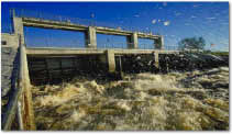
The urban and agricultural corridor of South Florida lies between the Everglades and Water Conservation areas to the west and the Atlantic Ocean to the east. This area includes eastern Dade, Broward, and Palm Beach Counties and is subject to widely conflicting stresses on the environment. The Shark River Slough, a deep water slough which historically channeled water from the eastern Everglades and moved water to the southwest, is located immediately west of this corridor. A highly controlled water management system has evolved during this century largely to provide drained land for a rapidly expanding population. Reclamation of Everglades wetland areas during the last 75 years provided the opportunity for westward expansion of agricultural, mining, and urban activities. In Water Conservation Areas that lie to the west of the protective levee system, surface water is impounded, partly to sustain an Everglades ecosystem, partly to keep overland sheet flow from moving eastward and flooding urban and agricultural areas, and partly for water supply. In coastal areas of the urban-agricultural corridor, parallel environmental conflicts exist. Coastal residential and urban areas must be drained for flood control; the underlying aquifer system must simultaneously serve as the principal source for water supply and heads must be maintained to prevent salt water intrusion. Changes in predevelopment ground-water flow patterns and the associated reduction in ground-water discharge to coastal bays has altered salinity in and affected the local ecology. The extensive canal network that incises the underlying unconfined aquifer has historically resulted in deleterious consequences: overdrainage, inland migration of coastal salt water and intrusion of these saline waters to nearby municipal well fields. The construction of canals and pumping from the surficial aquifer for water supply in south Florida has resulted in the lowering of water levels in the Everglades and in the aquifer. Consequently, the hydrodynamic balance between freshwater and saltwater in the ground-water flow system has changed, resulting in inland migration of saltwater into the freshwater aquifers. Coastal well fields used by many communities in South Florida are threatened, with some closed due to the inland movement of the saltwater. This synthesis will assess the hydrogeologic character of the surficial aquifer system, review the extensive impact of water-management controls on the hydrologic system, and examine the manner in which urban and agricultural areas have effected the ambient quality of ground water. In addition, this synthesis will examine the overall status of saltwater intrusion in South Florida, potential effects of Everglades restoration scenarios on intrusion, and the impact on water supply and the South Florida ecosystem due to saltwater intrusion. ProposalsWork PlansProject SummariesData
Metadata
PublicationsAbstracts
Circulars
Open File Reports
Papers
Posters
Water Resources Investigations Reports
|
U.S. Department of the Interior, U.S. Geological Survey
This page is: http://sofia.usgs.gov/projects/index.php?project_url=impact_auc
Comments and suggestions? Contact: Heather Henkel - Webmaster
Last updated: 24 September 2008 @ 01:45 PM (BJM)