USGS - science for a changing world

California Water Science Center

View of California Scenery - Photo by Cathy Munday, USGS

Skip navigation

ACTIVE STUDY AREAS ORGANIZED BY PROVINCE

Skip navigation

DATA CENTER


Google Maps access to CA hydrologic monitoring data
Precipitation
Streamflow
Ground-water Levels
Water Quality
Lakes

Skip navigation

ABOUT CALIFORNIA WSC

Skip navigation

USGS IN YOUR STATE


USGS Water Science Centers are located in each state.

There is a USGS Water Science Center office in each State. Washington Oregon California Idaho Nevada Montana Wyoming Utah Colorado Arizona New Mexico North Dakota South Dakota Nebraska Kansas Oklahoma Texas Minnesota Iowa Missouri Arkansas Louisiana Wisconsin Illinois Mississippi Michigan Indiana Ohio Kentucky Tennessee Alabama Pennsylvania West Virginia Georgia Florida Caribbean Alaska Hawaii New York Vermont New Hampshire Maine Massachusettes South Carolina North Carolina Rhode Island Virginia Connecticut New Jersey Maryland-Delaware-D.C.

Central Sacramento Valley Study Unit

Map of the Central Sacramento Valley Study Unit.

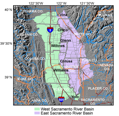
The Central Sacramento Valley Study Unit consists of 2 study areas:

  • West Sacramento River Basin (consists of Colusa and Corning Basins)
  • East Sacramento River Basin (consists of Vina, West and East Butte, West and East Sutter, and North and South Yuba Basins)

The 2 study areas fall in Butte, Colusa, Glenn, Tehama Sutter, Yolo, and Yuba counties.

Press release: Initial findings of central Sacramento valley groundwater study 3/5/2007

Accessibility FOIA Privacy Policies and Notices

Take Pride in America logo USA.gov logo U.S. Department of the Interior | U.S. Geological Survey
URL: http://ca.water.usgs.gov/gama/SU/cen_sacto.htm
Page Contact Information: GS-W-CAdist WWW
Page Last Modified: Friday, 03-Oct-2008 14:11:01 EDT