
USGS - VHP InSAR Research Group
PROJECT ABSTRACT
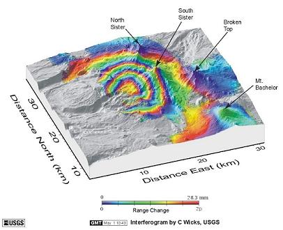
Interferogram showing uplift about 3 miles west of South Sister; Interferogram by C. Wicks
InSAR
This site provides mostly nontechnical information about InSAR, an exciting new remote-sensing technique used to study,
among other things, volcanoes and earthquakes. InSAR stands for Interferometric Synthetic Aperture Radar.
Satellites record images of the Earth's surface, and these images can be combined to show subtle movements of the ground surface,
called deformation.
InSAR is a proven technique for mapping ground deformation using radar images from Earth-orbiting satellites. InSAR greatly extends
the ability of scientists to monitor volcanoes because, unlike other techniques that rely on measurements at a few points, InSAR
produces a spatially complete map of ground deformation with centimeter-scale accuracy without subjecting field crews to hazardous
conditions on the ground. This project combines InSAR results with those from other geodetic techniques including the Global
Positioning System (GPS), borehole sensors such as dilatometers and tiltmeters, and precise leveling to characterize ground
deformation at volcanoes in space and time. The resulting data help to constrain models of the causes of volcanic unrest,
which in turn aids in the assessment of short-term volcano hazards. More detail can be found by
checking out the InSAR Fact Sheet: Monitoring Ground Deformation from Space
by Rosalind L. Helz.
The Research Group
The InSAR Research Group is composed of many scientists in various locations for the purpose of studying ground deformation. Find out who they are at the Group Members page. Learn more about what they do from information posted on the InSAR Research Results page.Learn more about InSAR.
Other methods for monitoring ground deformation:
EDM
| Tiltmeters
| GPS
What's new?
Research:
2008 Volcano Deformation and Temporal Gravity Change Workshop
The USGS Cascades Volcano Observatory held the 2008 Volcano Deformation and Temporal Gravity Change Workshop in Vancouver, WA, May 13 - 15 2008. Discussion topics included deformation monitoring, deformation modeling, and fluids and gravity studies.- Find out a little more about each InSAR Group Member here.
- InSAR Fact Sheet: Monitoring Ground Deformation from Space by Rosalind L. Helz and Figures from the Fact Sheet
- Current update of Mt. St. Helens activity.
- Mt. St. Helens is at Alert Level NORMAL; Aviation Color Code GREEN. (Click here for info on these levels.)
- Extended research information can be found at the InSAR Research Results page.
Website:
- Check out the new personal pages for each InSAR Group Member.
- Email the Webmaster with any comments you want to share about the website.
