 |
||||||||
| Home | About | Products | Data Tools | Order Data | News | Help/Edu | Links | Contact Us |
| EDG Data Set Name | Granule Shortname |
|---|---|
| MODIS/Aqua Land Surface Temperature/Emissivity Daily L3 Global 1km SIN Grid� | MYD11A1 |
| Version | Acquisition Range | Science Quality Status |
|---|---|---|
| V003 | March 6 2003 (2003065) - February 1 2004 (2004032) | Provisional |
| V004 | July 4 2002 (2002185) | Validated Stage 1 as of July 4, 2002 |
 Data Set Characteristics
Area = ~ 1100 x 1100 km
Image Dimensions= 2 (1200x1200 row/column)
Average File Size = 23 MB
Resolution = 1 kilometer (actual 0.93km)
Projection = Sinusoidal
Land Surface Temperature (LST) Data Type = 16-bit Unsigned Integer
Emissivity Data Type = 8-bit Unsigned Integer
Data Format = HDF-EOS
Science Data Sets (SDS) = 12
Product Description
MODIS Land Surface Temperature and Emissivity (LST/E) products provide
per-pixel temperature and emissivity values. Temperatures are extracted in
Kelvin with a view-angle dependent algorithm applied to direct observations.
This method yields 1 K accuracy for materials with known emissivities. The view
angle information is included in each LST/E product. Emissivities are estimates
derived from applying algorithm output to land cover database information. The
LST/E algorithms use MODIS data as input, including geolocation, radiance,
cloud masking, atmospheric temperature, water vapor, snow, and land cover. The
temperature products in turn are key inputs to many of the high level MODIS
products and provide data for global temperature mapping and change
observation. On land, soil and canopy temperature are among the main
determinants of the rate of growth of vegetation and they govern seasonal start
and termination of growth. Hydrologic processes such as evapotranspiration and
snow and ice melt are highly sensitive to surface temperature fluctuation,
which is also an important discriminating factor in classification of land
surface types.
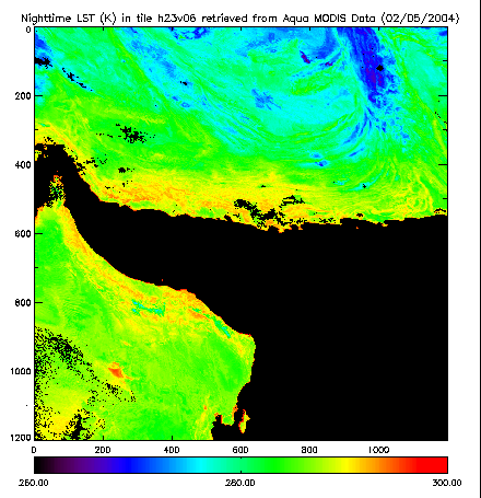
The false-colored image shown was retrieved February 5, 2004 over southern Iran and Afghanistan, west Pakistan, and Oman. The image is an example of the MODIS Level 3 LST daily product from Aqua at 1 km resolution. MYD11A1 is a geographically gridded version of the Level 2 daily LST product. It is generated by projecting MYD11_L2 pixels to Earh locations on a sinusoidal mapping grid.
NOTE: These products are validated, meaning that product uncertainties are well defined over a range of representative conditions. Although there may be later improved versions, these data are ready for use in scientific publications.
| SDS | Units | Data Type-bit | Fill Value | Valid Range | Multiply by Scale Factor |
Add ADDITIONAL OFFSET |
|---|---|---|---|---|---|---|
| Daily daytime 1km grid Land-surface Temperature | Kelvin | 16-bit unsigned integer | 0 | 7500 - 65535 | 0.0200 | na |
| *Quality control for daytime LST and emissivity | na | 8-bit unsigned integer | 0 | 0 - 255 | na | na |
| Time of daytime Land-surface Temperature observation | Hrs | 8-bit unsigned integer | 0 | 0 - 240 | 0.1000 | na |
| View zenith angle of daytime Land-surface Temperature | Degree | 8-bit unsigned integer | 255 | 0 - 130 | 1.0000 | -65.0000 |
| Daily nighttime 1km grid Land-surface Temperature | Kelvin | 16-bit unsigned integer | 0 | 7500 - 65535 | 0.0200 | na |
| *Quality control for nighttime LST and emissivity | na | 8-bit unsigned integer | 0 | 0 - 255 | na | na |
| Time of nighttime Land-surface Temperature observation | Hrs | 8-bit unsigned integer | 0 | 0 - 240 | 0.1000 | na |
| View zenith angle of nighttime Land-surface Temperature | Degree | 8-bit unsigned integer | 255 | 0 - 130 | 1.0000 | -65.0000 |
| Band 31 emissivity | na | 8-bit unsigned integer | 0 | 1 - 255 | 0.0020 | 0.4900 |
| Band 32 emissivity | na | 8-bit unsigned integer | 0 | 1 - 255 | 0.0020 | 0.4900 |
| Day clear-sky coverage | na | 16-bit unsigned integer | 0 | 0 - 65535 | 0.0005 | na |
| Night clear-sky coverage | na | 16-bit unsigned integer | 0 | 0 - 65535 | 0.0005 | na |
*MODIS Land Surface Temperature/Emissivity QA Science Data Sets
View a Version Formatted for Printing
Retrieve the MYD11A1v4 MODIS product through the LP DAAC Data Pool
Via Search Tool: http://e4eil01u.ecs.nasa.gov:22000/WebAccess/drill?attrib=esdt&esdt=MYD11A1.4&group=MOLA
Via FTP Directory: ftp://e4ftl01u.ecs.nasa.gov/MOLA/MYD11A1.004/
![]() Order These Data through the EOS Data Gateway
Order These Data through the EOS Data Gateway
MODIS/AQUA LAND SURFACE TEMPERATURE/EMISSIVITY DAILY L3 GLOBAL 1KM SIN GRID V004
EOS Data Gateway Search Tips
| Source: | Aqua |
|---|---|
| Sensor: | MODIS |
| Dataset: | MODIS/Aqua Land Surface Temperature/Emissivity Daily L3 Global 1km SIN Grid |
| Spatial: | HORIZONTALTILENUMBER Max/Min VERTICALTILENUMBER Max/Min |
| Geographic Extent: | Type Lat/Long Range or Draw on Map |
| Temporal Extent: | 2003-03-06 to 2004-02-01 (V003); 2002-07-04 to present (V004) |
Product Information
Contact Information
|
LP DAAC User Services U.S. Geological Survey (USGS) Earth Resources Observation and Science Center (EROS) 47914 252nd Street Sioux Falls, SD 57198-0001 |
|
|---|---|
| Phone: | 605-594-6116 |
| Toll Free: | 866-573-3222 |
| 866-LPE-DAAC | |
| Fax: | 605-594-6963 |
| Email: | LPDAAC@eos.nasa.gov |
| Web: | http://LPDAAC.usgs.gov |
| LP DAAC | EROS Home | About | Products | Data Tools | Order Data | News | Help/Edu | Links | Contact Us |
| This site is hosted by the USGS - NASA Distributed Active Archive Center U.S. Government: Public Information Exchange Resource NASA: Privacy Policy and Important Notices USGS: Privacy Statement, Disclaimer, Accessibility, FOIA DOI: Privacy Statement, Privacy Disclaimer, No FEAR Act, FOIA, Performance Plan, Children's Privacy URL: http://LPDAAC.usgs.gov/modis/myd11a1v4.asp Technical Contact: LPDAAC@eos.nasa.gov Last Update: Thursday, February 15, 2007 Download Adobe Acrobat Reader |
 |