Heavy Rain Leads to Erosion and Lahars
Leading edge of a debris flow triggered by heavy rain crashes down the Jiangjia Gully in China. The flow front is about 5 m tall. Such debris flows are common here because there is plenty of easily erodible rock and sediment upstream and intense rainstorms are common during the summer monsoon season.
These conditions commonly prevail after eruptions that kill vegetation over extensive areas and spread loose volcanic rocks over the landscape. During subsequent rainy seasons, swollen rivers will erode the new deposits and sometimes generate lahars that are dangerous to people downstream. Even if no lahars occur, the erosion can lead to frequent floods because of the deposition of sediment along the river channels.
Rain-triggered lahars at Mount Pinatubo, Philippines
Like thousands of other buildings downstream from Mount Pinatubo, this school house was buried by a lahar after the enormous eruption on June 15, 1991. In the first three months after the enormous eruption, more than 200 lahars swept Mount Pinatubo, destroyed roads and bridges, and buried farmland and towns with sediment. Thousands of lahars have occurred since 1991, and nearly all were triggered by intense rainfall.
Pyroclastic Flows Fill Valleys
Landscape before and after eruption.
Pyroclastic flows erupted by Mount Pinatubo profoundly changed the landscape around the volcano by filling river valleys with hot volcanic rocks as thick as 200 m and killing vegetation on nearby hillslopes. The pre-eruption landscape (upper photograph) consisted of unconsolidated prehistoric pyroclastic-flow deposits that were deeply eroded.
Pyroclastic flows from the June 15 eruption swept down each of the volcano's river valleys as far as 12 to 16 km (light-colored areas in lower photograph). With rainfall averaging between 2 to 4 m per year in this part of the Philippines, most of it falling in the monsoon season from June to October, thousands of small but destructive lahars originated from these pyroclastic-flow deposits.
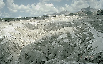
Water Erodes Gullies and New Stream Channels
During heavy rain after the eruption, water first collected in surface depressions on the pyroclastic-flow deposits and then spilled into adjacent low-lying areas. Within months, flowing water had eroded an elaborate network of deep gullies and stream channels into the deposits. Since the erosion took place in still-hot pyroclastic-flow deposits, sudden "steam" explosions were common in the first few years and the resulting lahars downstream were dangerously hot (40-70° C).
Sediment Raises River Channels
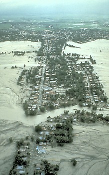
Heavy rain and erosion caused lahar after lahar downstream from Mount Pinatubo. During the rainiest periods in 1991, three to five lahars a day were common. As each new lahar carried sediment from the pyroclastic-flow deposits downstream, the volcano's river channels filled with sediment. Rising river channels caused frequent overbank flooding, even during normal streamflow. Here in the lower Abacan River east of Mount Pinatubo, floods and lahars spread into adjacent communities and valuable farmland.
Lahars and Floods Displace Thousands of People

Destroyed home


