|
 ENERGY PROGRAM NEWSLETTER ENERGY PROGRAM NEWSLETTER
CONTACT
Chris Potter,
Central Team Chief Scientist
303.236.1647
Additional Contacts>>

|
|
|
Colorado Plateau
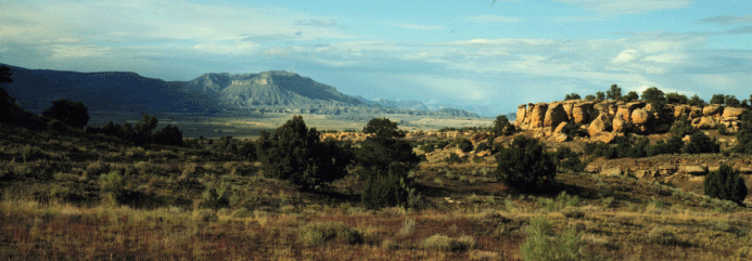 View of western part of Colorado Plateau in central Utah. Shale slopes in the distance are capped by the
Star Point Sandstone and coal-bearing Blackhawk Formation.
(from PP1625B, Chapter A.)
The Colorado Plateau is a physiographic province of the U.S. roughly
centered on the "Four Corners" area within western Colorado, northwestern
New Mexico, southeastern Utah, and northern Arizona. The terraine is
characterized by broad plateaus, ancient volcanic mountains and deeply
dissected canyons including the Grand Canyon. The area is semiarid,
sparsely vegetated, and sculpted by the Colorado River and its tributaries,
the Green, Little Colorado, and San Juan rivers. The region contains
substantial amounts of oil, gas, coal, oil shale, and uranium resources and
includes the San Juan, Uinta-Piceance, and Paradox Basins and Wasatch,
Black Mesa, and Kaiparowits plateau areas. This web site provides access to
the diverse Energy Resources Program research activities and products
within the Colorado Plateau Region.
NEW products
View of western part of Colorado Plateau in central Utah. Shale slopes in the distance are capped by the
Star Point Sandstone and coal-bearing Blackhawk Formation.
(from PP1625B, Chapter A.)
The Colorado Plateau is a physiographic province of the U.S. roughly
centered on the "Four Corners" area within western Colorado, northwestern
New Mexico, southeastern Utah, and northern Arizona. The terraine is
characterized by broad plateaus, ancient volcanic mountains and deeply
dissected canyons including the Grand Canyon. The area is semiarid,
sparsely vegetated, and sculpted by the Colorado River and its tributaries,
the Green, Little Colorado, and San Juan rivers. The region contains
substantial amounts of oil, gas, coal, oil shale, and uranium resources and
includes the San Juan, Uinta-Piceance, and Paradox Basins and Wasatch,
Black Mesa, and Kaiparowits plateau areas. This web site provides access to
the diverse Energy Resources Program research activities and products
within the Colorado Plateau Region.
NEW products
Facies Analysis and Sequence Stratigraphic Framework of Upper Campanian Strata (Neslen and Mount Garfield Formations, Bluecastle Tongue of the Castlegate Sandstone, and Mancos Shale), Eastern Book Cliffs, Colorado and Utah
By Kirschbaum, M.A., and Hettinger, R.D.
U.S. Geological Survey Digital Data Series DDS-69-G, Version 1.0, 58 p. [CD-ROM].
1 Reference(s) Found in This Search.

Coal mining and gas production from coal deposits are important contributors
to the generation of electric power in the United States. In the Western United States, large deposits of coal are concentrated in a
coherent physiographic and geologic province known as the Colorado Plateau,
located within the States of Arizona, Colorado, New Mexico, and Utah. The Plateau is not only an important coal-mining region but also
contains large natural gas resources that have been derived in part from the coal
deposits. (See PP1625-B)

The U.S. Geological Survey (USGS) recently completed an assessment of the undiscovered oil and gas potential of the Uinta-Piceance Province of northwestern Colorado and northeastern Utah. The assessment of the Uinta-Piceance Province is based on geologic principles and uses the total petroleum system concept. (See DDS 69-B)
Top of Page
|
|
 COLORADO PLATEAU SPOTLIGHT COLORADO PLATEAU SPOTLIGHT |
Assessment, Oil and Gas,
Uinta-Piceance, Utah and Colorado
DDS-69B
Assessment, Undiscovered Oil and Gas Uinta-Piceance Province of Colorado and Utah, 2002
Fact Sheet 026-02
Uinta-Piceance, Province 5020
DATA:
Coal Assessment, Colorado Plateau: Arizona, New Mexico, and Utah
PP-1625B
|
|
|
|
|

