 |
|
|
||||
| USGS › Geography › Earth Resources Observation and Science (EROS) Center |
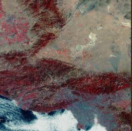
Landsat MSS Image (Los Angeles, CA)
Beginning September 30 2008, the USGS will offer all users the Landsat 7 archive data at no charge using a standard data product recipe. The Landsat TM and Landsat MSS archive will also become available at no charge with a standard recipe in December 2008.
At those times, the current products listed below will no longer be available for ordering. Please view the Landsat Web page for additional information.
The Landsat Multispectral Scanner (MSS) was a sensor onboard Landsats 1 through 5 and acquired images of the Earth nearly continuously from July 1972 to October 1992, with an 18-day repeat cycle for Landsats 1 through 3 and a 16-day repeat cycle for Landsats 4 and 5.
Landsat MSS image data consist of four spectral bands (band designations), although the specific band designations changed between Landsats 1-3 and Landsats 4-5. The resolution for all bands of 79 m, and approximate scene size is 170 km north-south by 185 km east-west (106 mi by 115 miles).
The following levels of correction are available to the general public.
The distribution of Landsat 1-5 MSS Precision Terrain correction data is restricted to U. S. Government and its affiliated users. Please contact USGS EROS Customer Services if you have questions regarding this policy.
For all levels of correction, the following processing parameters are customer-defined:
| Processing Parameters | Available options |
|---|---|
| Map projection | UTM Space Oblique Mercator Albers Equal-Area other* |
| Horizontal datum | WGS84 NAD83 NAD27 other* |
| Resampling method | cubic convolution (CC) nearest neighbor (NN) other* |
| Image orientation | Map (north up) Path (satellite; not recommended for UTM projection) |
| Pixel size | standard (57 meters) other* |
| Format | NDF (NLAPS Data Format) |
| Media Type | CD DVD FTP |
| Delivery Times | FTP: 1 to 3 days Media: 5 to 10 days The above are average delivery times and are not guaranteed. The actual delivery time may vary, depending on the workload at the time an order is placed. Delivery time may also be longer if shipping to a location outside the United States. |
*Other options may be available upon request.
| Product | Price |
|---|---|
| Systematic Correction | $200 per scene |
| Precision Correction | $300 per scene |
| Terrain Correction | $375 per scene |
A bulk discount of 20 percent off the standard product price will be applied to orders containing 25 or more single Landsat scenes (any combination of MSS, Thematic Mapper, and Enhanced Thematic Mapper Plus (ETM+) Scan Line Corrector (SLC)-on products are allowed).
All Landsat MSS scenes in the USGS archive can be searched by geographic location using Earth Explorer or the USGS Global Visualization Viewer (GloVis). Only scenes with browse capability can be searched and ordered on GloVis.
Landsat MSS data from satellites 1 through 3 are referenced to the Landsat Worldwide Reference System of paths and rows - WRS-1; Landsat MSS data from satellites 4 and 5 are referenced to WRS-2.
There are several commercial firms that can provide printed images from USGS digital data.
Landsat MSS images should always be previewed prior to purchase. Browse images of available scenes may be viewed by searching on Earth Explorer or GloVis.
Each Landsat MSS browse image is a resampled JPEG of the actual image data. The browse image will be displayed as a 4,2,1 (RGB) composite.
Landsat MSS product samples are available for download at the Landsat Sample Products Web page.
| Accessibility FOIA Privacy Policies and Notices | |
 |
|