U.S. Geological Survey - science for a changing world

Energy Resources Program

Coal - Coal Assessments
Energy Home | About Energy | Contact Energy | How Are We Doing?
Energy Sources Regional Studies Health and Environment Geochemistry and Geophysics Most Requested General Information Search Energy Publications and Data


Coal Assessments
Quick links below
Additional Topics

for our newsletterENERGY PROGRAM NEWSLETTER


CONTACT

Jim Luppens
Lead Geologist
703.648.6460


Valid XHTML 1.0 Transitional

Learn More about Coal Assessments

The Gillette coalfield portion of the PRB was evaluated in 2002.  For this study, detailed correlations for approximately 3100 drill holes were interpreted from existing NCRDES data.  In the past decade, the tremendous growth of coal bed methane well development in the PRB has resulted in completion of over 12,000 wells with publicly available corresponding geophysical logs.  This wealth of new data should greatly enhance the reliability and accuracy of future assessments in the region.
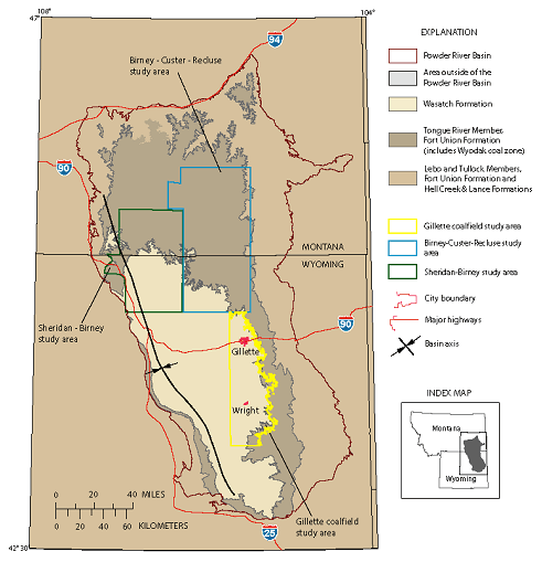
A map showing the location of the Gillette coal field.

A map showing the location of the Gillette coal field.

Top of Page


RECENT PUBLICATIONS

Large-scale digital geologic map databases and reports of the North Coal District in Afghanistan, (2008):
USGS Data Series 317 (dual-layer DVD-ROM).


RELATED LINKS

ASTM Committee D05 on Coal and Coke
Non-USGS Website

U.S. Energy Information Administration (EIA)
Non-USGS Website


Accessibility FOIA Privacy Policies and Notices

Take Pride in America home page. FirstGov button U.S. Department of the Interior | U.S. Geological Survey
URL:
Page Contact Information: ERP Webmaster
Page Last Modified: