Woods Hole Science Center
|
The Sediment Transport Instrumentation Facility at the USGS Woods Hole Field Center maintains and deploys oceanographic instrumentation for the study of coastal and ocean circulation and sediment transport. The time-series observations are used in studies of regional circulation, to document and understand processes of sediment transport (including major storms and catastrophic events), and provide observations for circulation and sediment transport model testing and evaluation. Instruments are typically deployed for 1-12 months in spatial arrays as part of process or long-term monitoring studies. The Facility is operated collaboratively with Northeast Fisheries Center of the Woods Hole National Marine Fisheries Service (National Oceanic and Atmospheric Administration , N.O.A.A.) and supports projects throughout the USGS Coastal and Marine Geology Program. The Facility maintains an extensive and wide range of sensors, data acquisition systems, and systems to deploy and recover instruments in the coastal and deep ocean.
|
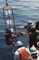 Figure 1: Vector measuring
current meter which uses orthogonal fans to measure currents, is recoverd from Massachusetts Bay. This instrument is also fitted with a transmissometer which measures light attenuation, a measure |
|
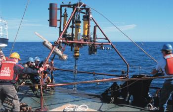
Bottom tripod systems (see fig. 2 above) (measures current, pressure, temperature, salinity, light transmission, photographs the bottom, and obtains pumped water samples for analysis of suspended matter). Acoustic Doppler Current Profilers measures profiles (typically in 1 m bins) of current throughout the water column. Micro-processor based data loggers for flexible data acquisition and sensor selection. Current meters (see fig. 1) suitable for both near-surface and deep measurements (measures current as well as temperature, salinity, and light transmission). Time series sediment traps (see fig. 3) (systems that accumulate suspended sediment over specified time intervals) Mooring systems for deployment and recovery of instrumentation in the coastal and deep ocean (surface marker floats, subsurface flotation, acoustic releases) An extensive software system is used to decode, process, edit, display, archive and analyze data. This system is developed and maintained cooperatively with the Woods Hole Oceanographic Institution, and is presently being upgraded to a platform independent system based on Matlab. Time series observations collected throughout the U.S. E.E.Z. since 1975 are archived and distributed to collaborators and other investigators over the World Wide Web. (see http://stellwagen.er.usgs.gov) |

Figure 3: A large funnel-shaped sediment trap that is used to collect suspended sediments in the water column.A carosel rotates a new sample bottleunderneath the collecting funnel every few days, collecting a time-series of sediment samples. These sediment traps are deployed beneath the sea surface on moorings for periods of 1-6 months. |

 U.S. Department of the Interior |
U.S. Geological Survey
U.S. Department of the Interior |
U.S. Geological Survey
URL: woodshole.er.usgs.gov/operations/sedtransfac/index.html
Page Contact Information: WHSC Webmaster
Page Last Modified: Thursday, 01-Feb-2007 08:00:35 EST