Alaska Volcano
ObservatoryWeekly UpdateFriday, October 24, 2008 11:00 AM AKDT (19:00 UTC)
KASATOCHI VOLCANO (CAVW #1101-13-)
52°10'9" N 175°30'41" W, Summit Elevation 1030 ft (314 m)
Current Aviation Color Code: YELLOW
Current Volcano Alert Level: ADVISORY
Seismicity at Kasatochi as determined from the network on Great Sitkin Island has been at a low level over the past week. On days with little cloud cover, a weak thermal anomaly within the Kasatochi crater has been consistently observed and is likely associated with the warm crater lake. AVO has received no additional observations about activity at Kasatochi volcano over the past week. The volcano appears to be returning to its normal background state.
Kasatochi Volcano does not have a seismic network, thus AVO depends on networks on neighboring islands to monitor earthquake activity there. For this reason, low-level seismicity may not be detected and renewed volcanic activity is possible at any time with little or no warning.
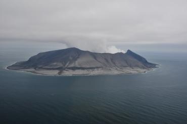
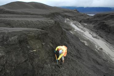
Kasatochi Island represents the emergent summit of a predominantly submarine volcano composed of basaltic and andesitic lava flows and pyroclastic deposits. The island consists of a single cone with a central circular crater with a diameter of 1.4 km. The maximum height of the crater rim is about 314 m. The volcano's most recent eruption began on August 7, 2008. This eruption produced ash clouds as high as 50,000 ft above sea level and pyroclastic-flow and surge deposits that cover the entire island to a depth of many meters. Prior the 2008 eruption, Kasatochi had no confirmed historical activity, although it is possible that eruptions attributed to nearby Konuiji volcano in 1760, 1827, and 1828 were actually minor eruptions of Kasatochi. Eruptive activity in 1899 may have destroyed a lake within the Kasatochi crater. Kasatochi is 83 km (52 mi) east of the community of Adak, and 90 km (55 mi) west of the community of Atka.
OKMOK VOLCANO (CAVW #1101-29-)
53°23'49" N 168°9'58" W, Summit Elevation 3520 ft (1073 m)
Current Aviation Color Code: YELLOW
Current Volcano Alert Level: ADVISORY
Seismic activity at Okmok Volcano has been at low to near background levels over the past week, although there have been a few very brief episodes of minor volcanic tremor. Satellite views of the volcano have been obscured by clouds most of the week, but in the few clear views this week, nothing unusual has been observed and no thermal anomalies have been detected. AVO has received no new information from passing boats or pilots about activity at Okmok this week.
Although the level of seismicity is relatively low, it is possible, but growing increasingly unlikely that vigorous ash emissions will resume.
Okmok volcano is a 6-mile-wide caldera that occupies most of the eastern end of Umnak Island, located 75 miles southwest of Dutch Harbor in the eastern Aleutian Islands. Okmok has had several eruptions in historic time typically consisting of ash emissions occasionally to over 30,000 feet ASL but generally much lower; lava flows crossed the caldera floor in 1945, 1958, and 1986. The last eruption occurred in February 1997 and was characterized by lava flows and intermittent ash emissions.
The nearest settlements are Nikolski, population about 35, roughly 45 miles west of the volcano, and a small number of people at the former Fort Glenn military base 10 miles east of the volcano.
OTHER ALASKA VOLCANOES
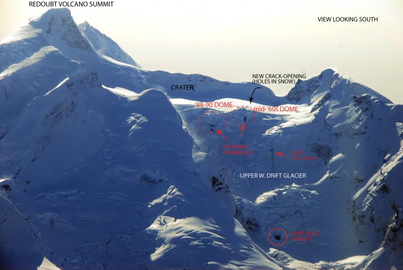
Seismic activity is monitored in real time at 31 volcanoes in Alaska. Satellite images of all Alaskan volcanoes are analyzed daily for evidence of ash plumes and elevated surface temperatures. Some volcanoes may currently display anomalous behavior but are not considered to be at a dangerous level of unrest. Augustine, Iliamna, Redoubt, Wrangell, Gareloi, Great Sitkin, Makushin, Fisher, Shishaldin, Isanotski, Pavlof, Veniaminof, Ugashik-Peulik, Griggs, Snowy, Fourpeaked, Aniakchak, Tanaga, Kanaga, Akutan, Westdahl, Dutton, Ukinrek Maars, Martin, Mageik, Trident, Katmai, Novarupta, Spurr, and Korovin volcanoes are in color code GREEN and volcano alert level Normal. All are at or near normal levels of background seismicity. AVO did not detect ash plumes or significant elevated surface temperatures in the vicinity of any volcano.
Please see http://www.avo.alaska.edu/color_codes.php for complete definitions of Aviation color codes and Volcano alert levels.
VOLCANO INFORMATION ON THE INTERNET: http://www.avo.alaska.edu
RECORDING ON THE STATUS OF ALASKA'S VOLCANOES (907) 786-7478
CONTACT INFORMATION:
Tom Murray, Scientist-in-Charge, USGS
tlmurray@usgs.gov (907) 786-7497
Steve McNutt, Coordinating Scientist, UAF
steve@giseis.alaska.edu (907) 474-7131
The Alaska Volcano Observatory is a
cooperative program of the U.S. Geological Survey, the University of
Alaska Fairbanks Geophysical Institute, and the Alaska Division of
Geological and Geophysical Surveys.