
U.S. Volcano Disaster Assistance Program
What is the Volcano Disaster Assistance Program (VDAP)?
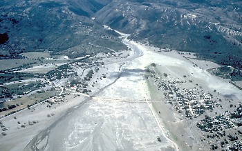
Aerial view of Armero destroyed by lahars from Nevado del Ruiz volcano, Colombia, on November 13, 1985
Less than a year after this disaster, however, the USGS and the U.S. Office of Foreign Disaster Assistance (OFDA) put together a team of volcano specialists and a cache of equipment that could be quickly dispatched to an awakening volcano if needed.
VDAP is a mobile volcano-response team that helps to saves lives in a volcano crisis.
Following the disastrous eruption of Nevado del Ruiz volcano, Colombia, that killed more than 23,000 people in 1985, the U.S. Geological Survey and U.S. Office of Foreign Disaster Assistance developed the Volcano Disaster Assistance Program (VDAP) to respond to selected volcanic crises around the world. The goal of VDAP is to reduce fatalities and economic losses in countries experiencing a volcano emergency. At the request of host countries and working through USAID, an experienced team of USGS and other scientists can rapidly respond to developing volcanic crises with a state-of-the-art portable cache of monitoring equipment. VDAP has proven to be effective in saving lives and property by assistance provided to local scientists for determining the nature and possible consequences of volcanic unrest and communicating eruption forecasts and hazard-mitigation information to local authorities.
VDAP is the only rapid-response volcano crisis team in the world. VDAP's most notable success occurred during the catastrophic eruptions of Mount Pinatubo in the Philippines in 1991. A quick response by VDAP and Philippine scientists to developing unrest resulted in rapid establishment of a monitoring network and completion of a hazard assessment, accurate eruption forecasts, and effective communication with Philippine Government officials and US military leaders. Evacuations and other civil-defense actions saved thousands of lives and hundreds of millions of dollars of US military aircraft and hardware.
Since the 1991 eruption of Mount Pinatubo, VDAP has responded to many volcano crises in Central and South America, the Caribbean, Africa. Asia, and the South Pacific. The new volcano-monitoring techniques developed by USGS scientists and the experience gained by VDAP scientists responding to volcano crises overseas help scientists to better protect people's lives and property from future eruptions of volcanoes in the United States. These international volcano responses enable scientists to test and refine monitoring methods and to increase their application for domestic volcanic crises.
Activities of the USGS Volcano Disaster Assistance Program
 |
We collaborate with local scientists.
As guests invited to assist in a response to a volcano emergency, we always work closely with scientists of the host country in planning the best way to improve their volcano-monitoring networks, installing instruments, interpreting monitoring data, and assessing volcano hazards. Due to urgency and danger from the volcano, this work is often performed under very stressful circumstances. |
|
 |
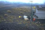
We can deploy a mobile volcano observatory
rapidly.
A mobile volcano observatory (stacked on pallet) was installed at Rabaul caldera in Papua New Guinea following an eruption that destroyed the monitoring network of the Rabaul Volcano Observatory on September 19, 1994; the system is still used to monitor restless activity at the caldera. |
|
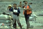 |
We assist in unraveling a volcano's history to identify
potential types and sizes of future eruptions and to produce volcano-hazard
zonation maps.
A quick examination of the geologic record at Mount Pinatubo, Philippines, as it was becoming restless between April and May 1991 clearly indicated the volcano's recent history of producing large explosive eruptions. This assessment helped to identify hazardous areas around the volcano before its cataclysmic eruption on June 15. |
|
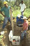 |
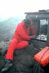
We work with other scientists to develop and install robust
volcano-monitoring instruments.
Many volcanoes that become restless have few or no historical eruptions, and are not monitored well. For example, after Soufriere Hills volcano in Montserrat became restless in 1995, we installed many new seismometers from our equipment cache (new seismic station shown here) to enable scientists to better monitor the volcano and to provide information needed by public officials to ensure public safety. |
|
 |
We apply lessons learned through our international
responses to better monitor volcanoes and reduce volcanic risk in
the United States.
Responding to volcano emergencies abroad provides critical field tests for monitoring instruments and broadens our experience so that we can better monitor volcanoes in the United States. Here, a new fortified seismic station is installed atop the lava dome at Augustine volcano, Alaska. |
|
Fact Sheets about the Volcano Disaster Assistance Program
|
Recent work of VDAP scientists
Map of VDAP Responses

Fogo (Cape Verde Islands), Nyiragongo and Nyamuragira, (D.R.O. Congo), Merapi (Indonesia), Mount Pinatubo (Philippines), Mayon (Philippines), Rabaul Caldera (Papua New Guinea), Popocat�petl (Mexico), Colima (Mexico), Pacaya (Guatemala), Cerro Negro (Nicaragua), Turrialba (Costa Rica), Guagua Pichincha (Ecuador), Tungurahua (Ecuador), Hudson (Chile), Sabancaya (Peru), Galeras (Colombia), Huila (Colombia), Unrest in SW Dominica, and Soufriere Hills (Montserrat)

![]() U.S. Department of the Interior |
U.S. Geological Survey
U.S. Department of the Interior |
U.S. Geological Survey
URL: http://volcanoes.usgs.gov/vhp/vdap.php
Page Contact Information: betavhpweb@usgs.gov
Page Last Modified: Wednesday, 23 April 2008 14:54:06 UTC