Untitled Document
Skip Navigation Linkswww.nws.noaa.gov 
NOAA logo - Click to go to the NOAA homepage National Weather Service Forecast Office   NWS logo - Click to go to the NWS homepage
WFO Lake Charles, LA
    

Local weather and forecast by
"City, St" or zip code
  
Hurricane warning flag Hurricane Rita Hurricane warning flag

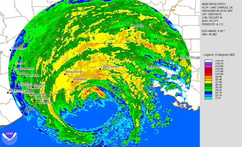
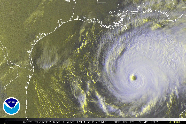
Hurricane Rita roared ashore near the Texas and Louisiana border during the pre-dawn hours of September 24, 2005. Rita was the strongest hurricane to strike Southeast Texas and Southwest Louisiana since Hurricane Audrey in June, 1957. Preliminary information suggests that Rita was comparable to Audrey in many ways, and perhaps worse in that the effects were felt across a larger area. A lot has changed in the 48 years since Audrey, and many lessons have been learned from her and other disasters that have affected this area during that time.

Hurricane Rita caused seven direct fatalities, three in the WFO Lake Charles county warning area. At least 55 indirect fatalities were associated with the evacuation and aftermath of Hurricane Rita, including six individuals in Beaumont, Texas who succumbed to carbon monoxide poisoning when they used a generator inside their building.  Although any loss of life is tragic, these numbers stand in stark contrast to the hundreds of lives lost due to Hurricane Audrey. Clearly, the improvements made to emergency preparedness and response to warnings have made a difference. The National Weather Service in Lake Charles looks forward to continuing and strengthening the partnerships we have formed with local emergency management, local media, and the residents of this region.

This section of our webpage has been created to provide the residents of Southeast Texas and Southwest Louisiana information about Hurricane Rita and its affect on the area. Below are some links that will bring you to pages with additional information of interest, along with a collection of image galleries (listed below) with pictures taken by the office staff.

We would like to extend our condolences to those who have and continue to suffer as a result of this destructive hurricane.


Hurricane Rita-related Reports
Hurricane Rita Report from NWS Lake Charles: A Comparison of Winds and Storm Surge
Hurricane Rita Report from the National Hurricane Center: PDF Format or MS Word Format
 
Graphical Overview of Hurricane Rita
Click on an image for a larger view
(note:  some images may take a while to load)
Hurricane Rita track
Hurricane Rita Track
Hurricane Rita estimated maximum wind gusts
Hurricane Rita Max Wind Gusts
Hurricane Rita estimated storm surge
Hurricane Rita Storm Surge

Post Tropical Cyclone Reports from NWS Offices
Lake Charles New Orleans Houston Fort Worth Corpus Christi

Radar and Satellite Data
 
The following DVDs contain satellite and radar animations of Hurricane Rita:
2005 Tropical Storms and Hurricanes Affecting the United States
2005 Atlantic Hurricane Season GOES Satellite Imagery
Click here for more information.
 
Some images and loops make take a while to load.
Lake Charles Short Radar Loop (animated gif) Lake Charles Long Radar Loop (java)
IR Satellite Loop of Rita Making Landfall Satellite Imagery from CIMMS
Visible Satellite Loop of Rita Near Peak Strength Satellite Imagery from NESDIS
Satellite Imagery from MODIS

Links of Interest
WFO LCH Rita Web Log Comparing Rita to Audrey NWS/EM Partnership
NOAA Aerial Damage Photos NOAA on Rita Aftermath NOAA on HAZMAT Response
NCDC Rita Summary HPC Rainfall Summary NASA Rita Coverage
NHC September Summary NHC Advisory Archive NHC Graphics Archive
WFO Houston Coverage WFO Shreveport Coverage AOML Coverage
NDBC Buoy Reports during Rita A Partnership for Rita
 
Photo Galleries
NWS Lake Charles office Lake Charles Downtown Lake Charles
Calcasieu Parish Cameron Cameron Parish
Jefferson Davis Parish St. Mary Parish Vermilion Parish
Jefferson County Orange County  

Page last modified: March 9, 2008 Privacy Policy