USGS - science for a changing world

Western Coastal & Marine Geology

Tsunamis & Earthquakes

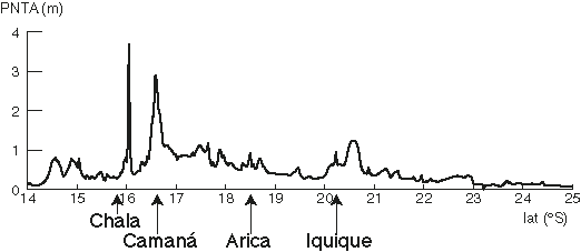
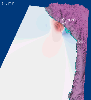
Preliminary Analysis of the Tsunami Generated by the 23 June 2001 Peru Earthquake

Table of Contents

Background

On June 23, 2001 a Mw=8.4 earthquake struck near the coast of Peru, 110 miles (175 km) west of Arequipa or about 370 miles (595 km) southeast of Lima. A tsunami was generated by this earthquake that killed at least 20 people in the Camaná-Chala region. The tsunami magnitude for this earthquake calculated by Katsuyuki Abe, Earthquake Research Institute, is Mt=8.1. A preliminary analysis of the tsunami generated by this earthquake is presented on this web page. For up-to-date information on the earthquake and its aftershocks in addition to news links for the earthquake and tsunami, please see the NEIC Bulletin for this event.

A model for tsunami generation and local propagation is presented here. For other models of far-field (trans-Pacific) propagation and observations of the tsunami, please see the NOAA/PMEL Web Link compilation for this tsunami.

Sedimentary deposits from the June 23, 2001 Peru tsunami were studied by a team of scientist from the US Geological Survey, University of California at Santa Cruz, University of Southern California, and government agencies and universities in Peru. Photographs of sedimentary deposits from the tsunami and field measurements of inundation distances and runup elevations are available at http://walrus.wr.usgs.gov/peru2/.

Tsunami Generation

We calculate the tsunami generated by this earthquake using a seismic inversion of the rupture process determined by Kikuchi and Yamanaka at the Earthquake Research Institute, Univ. of Tokyo, Japan (from 7/12/01). Using the shallow-dipping nodal plane consistent with an interplate thrust earthquake along the Peru subduction zone, they determine the moment distribution over a rupture area 210 km long by 120 km wide (Mw=8.2). Details of their analysis are given on the Special Event Page for the Peru earthquake.

To calculate a slip distribution for the earthquake, we use a depth-dependent shear modulus function derived by Bilek and Lay (2000) from the source duration analysis of past events in this region. Coseismic vertical displacement predicted for this earthquake is shown below (color scale represents uplift—surrounding area is subsidence):

Coseismic vertical displacement

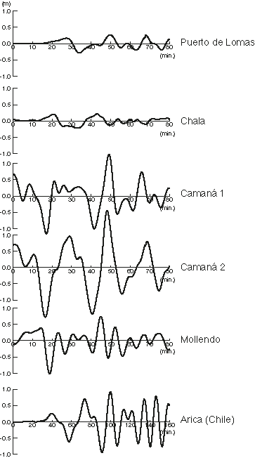
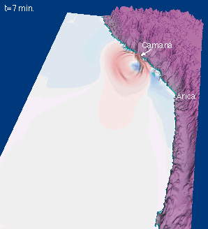
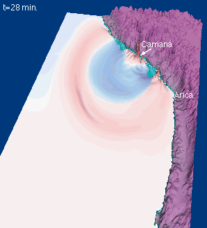
In performing these calculations, we note that not only does spatial variability of slip magnitude have a significant effect on the coseismic vertical displacement field (Geist and Dmowska, 1999), but variations in rake angle within the rupture zone also have a measurable effect on vertical surface displacement. The rupture process of this earthquake may be linked to initial arc-parallel stresses caused by the bend in the South American subduction zone in this region and/or subduction of the Nazca Ridge (Macharé and Ortlieb, 1992).

The Local Tsunami

Coseismic vertical displacement provides the initial conditions for tsunami propagation. Because the rupture area extended landward of the coastline, only part of the coseismic deformation was transferred to generating a tsunami. Local propagation is calculated using a finite-difference approximation to the linear long-wave equations and the 2-minute Smith and Sandwell (1997) bathymetric data (Copyright). An 8 s time step was used in the propagation model. Reflection boundary conditions were imposed at the 50 m isobath. At this water depth, synthetic marigrams near offshore coastal communities are shown below. The actual wave response at the coast would have been modified by nearshore bathymetric changes and shoaling of the wave.

Synthetic Marigrams

Please note that the time scale for the Arica, Chile synthetic marigram above is compressed by a factor of 2 (0-160 min.) compared to the other stations (0-80 min.). For comparison to other modeling efforts that include tide gauge stations at greater distances, see the NOAA/PMEL Web Link compilation page. As with other observed tsunamis, there are multiple waves that impact the coastline, arising from complex reflections and trapped modes. In most cases, the first/direct arrival is not the largest wave.

In addition to the synthetic offshore marigrams above, the predicted peak nearshore tsunami amplitude (PNTA) for the Peru/Chile coastline (14°-25° S) is shown below:

PNTA distribution

Tsunami runup can be roughly approximated by applying an amplification factor of 2 to the above PNTA values. Non-linear and overland flow models can more accurately simulate tsunami runup than the model used here. Maximum values of PNTA are located along the Chala-Camaná coastline of Peru, consistent with preliminary reports. In addition, there appears to be a secondary peak in PNTA south of Iquique, Chile. Shown below are snapshots from the tsunami propagation model (red-positive amplitude; blue-negative amplitude). Both the wavefield and topography are vertically exaggerated.

tsunami at t=0 min.
tsunami at t=7 min.
tsunami at t=28 min.
tsunami at t=38 min.

Tsunami animations for the first 33 minutes of the local tsunami are available in QuickTime format through the following links:

Medium Resolution Movie, 527x463 pixels
Warning: Cumulative file size at this link approx. 4.3 MB

High Resolution Movie, 527x463 pixels
Warning: Cumulative file size at this link approx. 24.0 MB

Note: These QuickTime* movies are very large and may take a few minutes to download. Movies are a non-standard part of the internet and may not load for all viewers. If you do not have QuickTime please download the QuickTime Player here.*

*Any use of trade, product, or firm names is for descriptive purposes only and does not imply endorsement by the U.S. Government.

Future Efforts

This model will be refined as more information is obtained about the earthquake. Because of the tectonic complexity of this region, future research efforts will likely incorporate a finite-element model of tsunami generation (Yoshioka et al., 1989). In addition, this model will be tested as more observations of local tsunami runup are obtained. We will report our results on this web page as the model is updated.

References Cited

Bilek, S. L., and T. Lay, 2000. Depth dependent rupture properties in Circum-Pacific subduction zones: In, GeoComplexity and the Physics of Earthquakes, J. B. Rundle, D. L. Turcotte, and W. Klein, eds., Geophys. Mon. 120, Am. Geophys. U., p. 165-186.

Geist, E.L., and R. Dmowska, 1999. Local tsunamis and distributed slip at the source: Pure Appl. Geophys., v. 154, p. 485-512.

Macharé, J., and L. Ortlieb, 1992. Plio-Quaternary vertical motions and the subduction of the Nazca Ridge, central coast of Peru: Tectonophysicics, v. 205., p. 97-108.

Smith, W. H. F., and D. T. Sandwell, 1997. Global Sea Floor Topography from Satellite Altimetry and Ship Depth Soundings: Science, v. 277, p. 1956-1962.

Yoshioka, S., M. Hashimoto, and K. Hirahara, 1989. Displacement fields due to the 1946 Nankaido earthquake in a laterally inhomogeneous structure with the subducting Philippine Sea plate—a three-dimensional finite element approach: Tectonophysics, v. 159, p. 121-136.

Web page produced by

Eric Geist (USGS, Coastal & Marine Geology) with help from
Shoichi Yoshioka (Kyushu Univ., visiting Geological Survey of Canada)
Susan Bilek (UC Santa Cruz)
Kenji Hirata (JAMSTEC, visiting USGS)
We thank Prof. Kikuchi for supplying us with digital seismic inversion results.


 Tsunamis and Earthquakes  Home  Search our site

Accessibility FOIA Privacy Policies and Notices

Take Pride in America logo USA.gov logo U.S. Department of the Interior | U.S. Geological Survey
URL: http://walrus.wr.usgs.gov/tsunami/Peru01.html
Page Contact Information: Laura Zink Torresan
Page Last Modified: 2 September 2008 (lzt)