
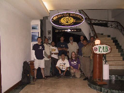
Leg 1 Team at Saraina Koat Mentawai office in Pandang prior to boarding the MV Seimoa; March 30, 2005.
FIELD STUDY OF THE EFFECTS OF THE MARCH 28, 2005, and DECEMBER 26, 2004, TSUNAMIS IN SUMATRA
- Daily USGS field reports
- Tsunami research at the USGS
- Tsunami event - 28 March 2005, NOAA
- Tsunami event - 26 December 2004, NOAA
The West Sumatra International Tsunami Survey Team (ITST) is composed of U.S. and Indonesian tsunami scientists. The team travelled by boat from March 30 to April 26 to collect critical data to collect data to document the decay in the December 26, 2004, tsunami from northern to southern Sumatra. The team will also determine the size of the March 28, 2005, tsunami. Goals of the data collection effort were:
- to determine how large a tsunami was created by the March 28, 2005 earthquake;
- to fill in the gaps in the December 26, 2004, tsunami measurements of wave height, runup, and inundation distance between Lhoknga (northern Sumatra) and Padang (southern Sumatra);
- to do detailed sedimentological investigations, including paleotsunami studies;
- to collect nearshore bathymetry, filling a critical data void for tsunami propagation modeling;
- to investigate the effectiveness of previous education and mitigation strategies;
- to make additional estimates of co-seismic subsidence; and
- to measure groundwater salinity in coastal aquifers.
ANTICIPATED PROJECT OUTCOMES:
Anticipated outcomes from this scientific effort include a better understanding of the March 28, 2005, and December 26, 2004, Indian Ocean tsunamis; an improved history of tsunami size and frequency on the west coast of Sumatra; and development of methods for interpreting past tsunami events in Sumatra and elsewhere in the world.
This information can be used by local government officials to help mitigate against future tsunami hazards in Indonesia, and by other coastal communities to help manage coastal development (for example, to decide where to build public buildings or infrastructure). In addition, by sharing research techniques and methodology with scientists from Indonesia, we hope to transfer the skills necessary to allow local scientists to better evaluate tsunami hazards.
DETAILS OF THIS ACTIVITY:
USGS co-led a team of 12 US and 5 Indonesian scientists to collect data on the recent tsunamis. The team took measurements on mainland Sumatra from Banda Aceh to Padang and offshore islands including Nias, Simeulue, and the Banyaks. Because roads are still out and will likely be out for an extended period of time, the team travelled by charter boat from March 30 to April 26 to collect the needed data.
Strategy: Have two 14-day legs to allow more data collection, more scientists to participate, a phased-approach where information from the 1st leg dictates the locations where data is collected in a sediment-oriented 2nd leg.
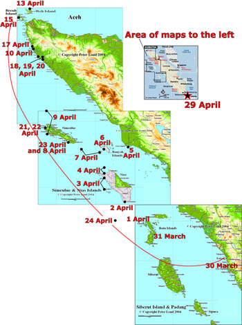
Base maps of Indonesia © copyright Peter Loud 2004;
used with permission. Additional maps at
URL http://www.peteloud.co.uk/.
Map of western Sumatra showing approximate location of survey team each day. Long line represents the area of the survey; dates, dots, and stars indicate approximate locations of the survey team when the daily reports were given. For more information, see the daily USGS field reports. See a larger version of the map (150 kb).
Leg 1 (S-1-05-IN) : March 30-April 12; Padang to Banda Aceh
Main focus: Water level measurements. Move quickly up the coast going ashore 2 to 4 times a day to collect as many wave height, run-up, and profile measurements as possible. Collect detailed bathymetry in shallow and intermediate water depths at some of the sites. Conduct reconnaissance for easy and safe shore access and sediment transect sites.
Additional focuses: Sedimentation and erosion, paleotsunami deposits, uplift and subsidence, groundwater salinity. These studies would be done in the same time frame (rapid) as the water level and profile measurements.
Leg 1 Scientists:
- Jose Borrero, Leg 1 Leader (USC)
- Gegar Sapta Prasetya (Tsunami Research Center - BPPT/DKP)
- Vasily Titov (NOAA PMEL)
- Widjokongko (Tsunami Research Center/Coastal Dynamic Research Center - BPPT)
- Brian McAdoo (Vassar)
- Bob Peters (USGS)
- Rahman Hidayat (Tsunami Research Center/Coastal Dynamic Research Center - BPPT)
- Bretwood Higman (University of Washington)
- Etienne Kingsley (USGS Contractor)
- Lukianto (Natural Resources Inventory technology Research Center - BPPT)
Leg 2: April 13-April 26; Banda Aceh to Padang
Main Focus: Tsunami sediments. Use wave level measurements and reconnaissance from 1st leg to pick sites for detailed sediment work.
Additional focuses: Uplift and subsidence, paleotsunami deposits, vegetation impacts of inundation. These studies would be done in the same time frame (slow) as the sediment transect measurements.
Leg 2 Scientists:
- Bruce Jaffe, Leg 2 Leader (USGS)
- Guy Gelfenbaum (USGS)
- Peter Ruggiero (USGS)
- Bob Morton (USGS)
- Widjokongko (Tsunami Research Center/Coastal Dynamic Research Center - BPPT)
- Andy Moore (Kent State)
- Lori Dengler (Humboldt State)
- Bretwood Higman (University of Washington)
- Eko Yulianto (The Indonesian Institute of Science)
The West Sumatra International Tsunami Survey Team:
- Bruce Jaffe (USGS)
- Gegar Sapta Prasetya (Tsunami Research Center - BPPT/DKP)
- Jose Borrero (USC)
- Guy Gelfenbaum (USGS)
- Peter Ruggiero (USGS)
- Bob Morton (USGS)
- Bob Peters (USGS)
- Etienne Kingsley (USGS Contractor)
- Subandono Diposaptono (Subdirectorate Marine Environment Disaster Mitigation - DKP)
- Rahman Hidayat ( Tsunami Research Center/Coastal Dynamic Research Center - BPPT)
- Lukianto (Natural Resources Inventory technology Research Center - BPPT)
- Widjokongko (Tsunami Research Center/Coastal Dynamic Research Center - BPPT)
- Vasily Titov (NOAA PMEL)
- Andy Moore (Kent State)
- Brian McAdoo (Vassar)
- Lori Dengler (Humboldt State)
- Bretwood Higman (University of Washington)
- Eko Yulianto (The Indonesian Institute of Science)
ACKNOWLEDGMENTS: Participation of USGS scientists on the team is funded by the Coastal & Marine Geology Program and the U.S. Agency for International Developments Office of Foreign Disaster Assistance. Dr. Bruce Jaffe, USGS, is co-leader of the West Sumatra International Tsunami Survey Team.
MORE INFORMATION on tsunamis and earthquakes:
- The 26 December 2004 Indian Ocean Tsunami: Initial Findings from Sumatra
http://walrus.wr.usgs.gov/tsunami/sumatra05/ - The December 26, 2004 Indian Ocean Tsunami: Initial Findings on Tsunami Sand Deposits, Damage, and Inundation in Sri Lanka
http://walrus.wr.usgs.gov/tsunami/srilanka05/ - Tsunami Generation from the 2004 M=9.0 Sumatra Earthquake
http://walrus.wr.usgs.gov/tsunami/sumatraEQ/ - Compilation of the 26 December 2004 Indonesian Earthquake and Tsunami by NOAA:
http://www.pmel.noaa.gov/tsunami/sumatra20041226.html - Compilation of the 28 March 2005 Indonesian Earthquake and Tsunami by NOAA:
http://www.pmel.noaa.gov/tsunami/indo20050328.html - USGS Earthquakes & Tsunamis Home Page:
http://walrus.wr.usgs.gov/tsunami/
DISCLAIMER: This material is preliminary and has not been reviewed for conformity with U.S. Geological Survey editorial standards or with the North American Stratigraphic Code. Any use of trade, firm, or product names is for descriptive purposes only and does not imply endorsement by the U.S. Government.
 |
 |
 |
 |
|
 |
 |