- NASA Home
- | Missions
- | Hurricanes
- | Archives
- | 2006
Featured Images
Hurricane Season 2006: Ernesto (Atlantic)
09.01.06
NASA has been keeping a close eye on Tropical Depression Ernesto. Ernesto was a tropical storm that made landfall in Cuba, Florida and finally North Carolina. Ernesto is now bringing wet weather to the Mid-Atlantic and northeast for the Labor Day weekend.
Where is Ernesto and Where is He Heading?
As of 3:00 p.m. EDT, the center of Tropical Depression Ernesto was moving from Virginia northward to Maryland on a northern track for upstate New York. The National Hurricane Center expects rainfall totals of 4 to 7 inches in the Mid Atlantic states including the central Appalachians from Virginia northward through Sunday with isolated maximum storm totals of up to 12 inches possible.
What Did Ernesto Do To the Carolinas and Virginia?
South Carolina may have missed Ernesto's landfall, but North Myrtle Beach, S.C. reported almost 7 inches of rainfall. Tropical Storm Ernesto did make landfall in North Carolina around 11:30 p.m. Thursday, Aug. 31, near Southport. The National Weather Service reported that rainfall of up to 10 inches caused problems on some on North Carolina highways. Surf City, N.C. reported 12 inches of rain. The strongest wind gust was 74 mph, reported at Wrightsville Beach, N.C. and on Friday morning, Sept. 1, almost 80,000 people had no electricity. As Ernesto moved north, parts of Virginia received up to 6 inches of rain, flooding highways and knocking out power. Dominion Virginia Power reported that about 150,000 customers lost power in the southeast part of the state, while near Richmond, 39,000 people had no power.
An Inside Satellite Look at Ernesto's Clouds

Click on image to enlarge.
This is an infrared image of Tropical Storm Ernesto, from the Atmospheric Infrared Sounder (AIRS) on NASA's Aqua satellite on Sept. 1, 2006 at 6:35 UTC (2:45 a.m. EDT). This AIRS image shows the temperature of the cloud tops or the surface of the Earth in cloud- free regions. The lowest temperatures (in purple) are associated with high, cold cloud tops that make up the top of the storm. The infrared signal does not penetrate through clouds. Where there are no clouds the AIRS instrument reads the infrared signal from the surface of the Earth, revealing warmer temperatures (red).
Ernesto's Heaviest Rainfall Over Eastern North Carolina Early 9/1/06
Click on image to enlarge.
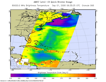
The second image is created from microwave radiation emitted by Earth's atmosphere and received by the instrument. It shows where the heaviest rainfall is taking place (in blue). In this image, captured at 2:45 a.m. EDT on Sept 1, Ernesto's heaviest rainfall was taking place over eastern North Carolina. Blue areas outside of the storm where there are either some clouds or no clouds, indicate where the sea surface shines through.
CloudSat and GOES Satellites Get 2 Views of Ernesto

Click on image to enlarge.
These two images satellite images in the same frame are from two different satellites, giving a top-down and sideways view of Tropical Depression Ernesto, on Aug. 31, 2006 at 18:45 UTC (2:45 p.m. EDT) as he was about to make landfall in South Carolina.
The top image is from the National Oceanic and Atmospheric Administration's Geostationary Operational Environmental Satellite (GOES) to give an idea of how the storm looked from the top. This data was processed by NASA's GOES Project at the Goddard Space Flight Center, Greenbelt, Md. The black line shows the track that NASA's CloudSat satellite took as it passed to the right side of Ernesto's center.
The CloudSat image (bottom) shows a side-view of Ernesto on Aug. 31. At this time Ernesto was a tropical storm building to sustained winds near 70 mph. The red and purple areas on the CloudSat image (bottom) indicate large amounts of cloud water. The blue areas along the top of the clouds indicate cloud ice, while the wavy blue lines on the bottom center of the image indicate intense rainfall. Notice that the solid line along the bottom of the panel, which is the ground, disappears in these areas of intense precipitation. It is likely that in the area the precipitation rate exceeds 30mm/hr (1.18 inches/hour) based on previous studies. AIRS Images Credit: NASA/JPL -- CloudSat Image credit: NASA/JPL/The Cooperative Institute for Research in the Atmosphere (CIRA), Colorado State University/NOAA -- Caption: Rob Gutro, NASA/GSFC, from NHC reports
Tropical Depression Ernesto Soaking the Mid-Atlantic, Heading North
Ernesto, now a tropical depression as of 11:00 a.m. EDT on Fri. Sept. 1, was soaking the mid-Atlantic on its northward trek toward Canada. At 11:00 a.m. EDT, gale warnings are now effect for the Atlantic coast and the Chesapeake Bay from Surf City, North Carolina northward into New England coastal waters.
Where is Ernesto Going?
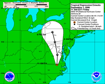
The National Hurricane Center forecast at 11:00 a.m. EDT on Sept. 1 takes Ernesto through eastern Virginia, then curving northwest over western Maryland early Sat. Sept. 2, and into north central Pennsylvania by 8 p.m. Sat. night. Ernesto's remnants may reach Canada on Sunday.
Where is Ernesto and What is His Status?
At 11:00 a.m. EDT the center of Tropical Depression Ernesto was located near latitude 36.4 north, longitude 77.6 west or about 80 miles west-southwest of Norfolk, Virginia. Ernesto is moving toward the north near 14 mph Maximum sustained winds are near 35 mph with higher gusts. Estimated minimum central pressure is 992 millibars.
High Rainfall Totals Expected in the Mid-Atlantic
Rainfall totals of 4 to 7 inches are expected over the Mid-Atlantic states, including the central Appalachians, from Virginia northward through Sunday with isolated maximum storm totals of up to 12 inches possible. Additional 2 inch rainfall amounts are possible over extreme northeastern North Carolina through Friday afternoon. Life-threatening flash floods and mud slides are possible with these rains.
Isolated Tornadoes Possible
Isolated tornadoes are possible over extreme eastern North Carolina and southeastern Virginia through today.
An Inside Satellite Look at Ernesto's Clouds
Click on image to enlarge.
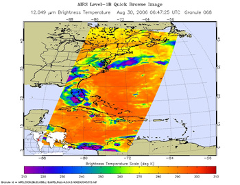
This is an infrared image of Tropical Storm Ernesto over Florida, from the Atmospheric Infrared Sounder (AIRS) on NASA's Aqua satellite on August 30, 2006. This AIRS image shows the temperature of the cloud tops or the surface of the Earth in cloud- free regions. The lowest temperatures (in purple) are associated with high, cold cloud tops that make up the top of the storm. The infrared signal does not penetrate through clouds. Where there are no clouds the AIRS instrument reads the infrared signal from the surface of the Earth, revealing warmer temperatures (red).
Where was Ernesto's Heaviest Rainfall Over Florida?
Click on image to enlarge.
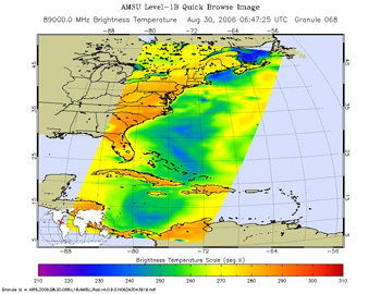
The second image is created from microwave radiation emitted by Earth's atmosphere and received by the instrument. It shows where the heaviest rainfall is taking place (in blue) in the storm. Blue areas outside of the storm where there are either some clouds or no clouds, indicate where the sea surface shines through.
Forecast Storm Track for Tropical Depression Ernesto
Click on image to enlarge.
This image is the forecast track for Tropical Depression Ernesto over Labor Day weekend. By Sat. night, Sept. 3, Ernesto is expected to be in north western Pennsylvania headed toward Canada.
Ernesto Targeting the North and South Carolina Coasts
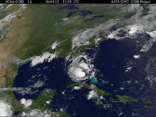
Click image to view movie.
Tropical Storm Ernesto has already made landfall in Cuba and Florida, and is now eyeing the Carolinas for its third and final landfall late on Aug. 31. This is a movie created by images from the National Oceanic and Atmospheric Administration's (NOAA) Geostationary Environmental Operational Satellite (GOES). It combines satellite images from Aug. 28 at 9:25 a.m. EDT (12:25 UTC) through Aug. 31 at 9:15 a.m. EDT (12:15 UTC), and shows Tropical Depression Ernesto coming off of Cuba and back into open waters as a tropical depression. Then Ernesto made landfall in south Florida, and exited Florida's east coast into the open waters of the Atlantic Ocean where it regained Tropical Storm status. This data was processed by NASA's GOES Project Science Office at the Goddard Space Flight Center, Greenbelt, Md.
Where is Ernesto Now?
According to the National Hurricane Center (NHC) at 8:00 a.m. EDT, the center of Tropical Storm Ernesto was located near latitude 30.4 north, longitude 79.9 west or about 95 miles east of Jacksonville, Florida and about 170 miles south of Charleston, South Carolina. Ernesto is moving toward the north near 15 mph and a gradual turn toward the north-northeast and a faster forward speed are expected during the next 24 hours. This motion will take the center of Ernesto farther away from the coast of northeast Florida today and could bring the center near the north and South Carolina coasts late this afternoon or tonight. Maximum sustained winds have increased to near 55 mph with higher gusts. Some strengthening is forecast during the next 24 hours. Tropical storm force winds extend outward up to 85 miles mainly to the southeast of the center. Latest minimum central pressure reported by an air force plane was 996 millibars. A tropical storm warning remains in effect from Flagler Beach, Florida to Cape Lookout, North Carolina.
What's In Store for Georgia and the Carolinas?
Coastal storm surge flooding of 3 to 5 feet above normal tide levels is possible along the coasts of south and North Carolina in areas of onshore flow within the warning area. Coastal storm surge flooding of 1 to 3 feet above normal tide levels is possible along the Georgia coast. Isolated tornadoes are possible over eastern North Carolina late this afternoon and tonight.
Extreme Rainfall Possible in Mid-Atlantic and Appalachians
Rainfall totals of 4 to 8 inches are possible from northeast South Carolina into the Mid-Atlantic states and the southern and central Appalachians with isolated maximum amounts of 12 inches through Saturday. These amounts could cause life-threatening flash floods. Additional isolated rainfall amounts of 1 to 2 inches are possible over Florida today.
Where is Ernesto Headed?
National Hurricane Center forecasts predict another landfall for Ernesto late Thurs. night, Aug. 31 on the South Carolina/North Carolina border. From there, Ernesto is forecast to take in inland track as a tropical depression, and dissect the middle of North Carolina on its northward track. Ernesto is forecast to go through central Virginia, western Maryland, western Pennsylvania and New York state and into Canada by early Sunday, Sept. 3.
Ernesto Moves Along Florida Coast Towards South Carolina

Click image to enlarge.
This image from The Tropical Rainfall Measuring Mission (TRMM) satellite was taken 0254 UTC 30 August (10:54 p.m. EDT August 29) and captures Ernesto just as the center was making landfall on the coast of south Florida. Most of the rain shield (broad blue arc) is well ahead of the center of circulation. The center itself is rather devoid of rain (note the patch of light rain in blue near the southern tip of the peninsula). At landfall, the National Hurricane Center reported that Ernesto's maximum sustained winds were 40 knots (46 mph).
Initial reports indicate only minimal damage from the storm in Florida. Ernesto, however, is expected to continue to make its way up the eastern seaboard and could regain some strength over the western Atlantic if it follows the projected path. The biggest impact from the storm could be in the form of heavy rains if as expected it merges with an approaching frontal system later in the week. TRMM is a joint mission between NASA and the Japanese space agency JAXA.
Where is Ernesto on Tues. Aug. 29?
At 2:00 p.m. EDT the center of Tropical Depression Ernesto was moving over Lake Okeechobee, Florida. It is near latitude 26.9 north, longitude 80.9 west or about 60 miles south-southeast of Vero Beach, Florida. Ernesto is moving to the north near 10 mph and is expected to continue. This general motion is expected to continue today with a gradual turn to the north-northeast along the Florida peninsula. On this track the center should move over the Atlantic waters late tonight. Maximum sustained winds have decreased to near 35 mph. The estimated minimum central pressure is 1003 millibars.
Possible Conditions in Florida, South Carolina
Rainfall totals of 3 to 5 inches are possible near the track of Ernesto over the Florida peninsula with isolated amounts up to 10 inches possible. Rainfall totals of 4 to 8 inches are possible from coastal South Carolina northward into the Mid-Atlantic region with maximum amounts of 12 inches over the next few days.
What's Next for Ernesto?
The National Hurricane Center noted that there is potential for Ernesto to re-intensify once it moves over the Atlantic waters late tonight, Aug. 30 Computer models bring Ernesto to the southeast U.S. coast in about 36 hours. Once inland and beyond 48 hours Ernesto should begin to interact with a frontal system and become extratropical. The forecast track, as of Aug. 30 at 2 p.m. EDT, carries Ernesto out of Florida into the Atlantic, and making landfall along the South Carolina coast as a tropical storm late Thurs. Aug. 31. From there, Ernesto is forecast to track through central North Carolina, Virginia, western Maryland and into central Pennsylvania bringing all of those areas heavy rainfall. Images produced by Hal Pierce (SSAI/NASA GSFC) and caption by Steve Lang (SSAI/NASA GSFC).
Ernesto Already Affecting South Florida
At 2:00 p.m. EDT on Tues. Aug. 29, the outer rainbands of Tropical Storm Ernesto are spreading over the Florida Keys and southeast Florida coast, and some strengthening still expected by the National Hurricane Center.
Where is Ernesto?
At 2:00 p.m. EDT the center of Tropical Storm Ernesto was located near latitude 23.9 north, longitude 79.7 west or about 135 miles southeast of Key West, Florida and about 135 miles south-southeast of Miami, Florida. Ernesto is moving toward the northwest near 13 mph and this general motion is expected to continue for the next 24 hours. On the forecast track the center of Ernesto will be near the Florida Keys or southeast Florida by this evening. Rainbands and squalls are already moving onshore during the late afternoon/evening of Aug. 29. Maximum sustained winds are near 45 mph with higher gusts. Some strengthening is forecast during the next 24 hours. Tropical storm force winds extend outward up to 85 miles from the center. The estimated minimum central pressure is 1008 millibars.
Watches and Warnings for Florida and Georgia's Coast
A Tropical Storm Warning extends in Florida from Englewood (just south of Venice) on Florida's west coast, south through the Keys and Everglades, and on the east coast all the way north to Altamaha Sound, Georgia. A tropical storm warning and/or a hurricane watch will likely be required for the remainder of the Georgia coast and for the South Carolina coast later today.
Rainfall, Isolated Tornadoes, Storm Surge
Hurricane warnings may be needed for parts of south Florida and the Keys later today. Rainfall totals of 5 to 10 inches are possible over portions of eastern and southern Florida and the Keys through Wednesday, with isolated amounts up to 15 inches possible over southeastern Florida.
Isolated tornadoes are possible over southern Florida including the Keys this evening and tonight. Coastal storm surge flooding of 1 to 3 feet above normal tide levels can be expected in areas of onshore flow within the warning area.
Live Radar of South Florida
For a live look at the rainfall from Ernesto, go to the National Weather Service Website Key West, Fla. Radar Loop: + Key West Radar Loop
More Watches and Warnings
A tropical storm warning and a hurricane watch remain in effect for Andros Island, the Berry islands, the Biminis and Grand Bahama Island in the northwestern Bahamas. A tropical storm warning remains in effect for ragged island and Great Exuma in the central Bahamas. Rainfall amounts of 1 to 2 inches with possible isolated amounts of 3 to 6 inches are possible over the Bahamas. All watches and warnings have been discontinued in Cuba.
NASA's TRMM Satellite Sees Rainfall in Ernesto

Click image to enlarge.
This image was taken from the Tropical Rainfall Measuring Mission (TRMM) satellite and was taken at 1134 UTC (7:34 am EDT) on Aug. 26 as Ernesto was passing south of the Dominican Republic. At this time intense areas of rain are present within the storm (red areas) and indicate areas of active convection (rapidly rising air that forms thunderstorms). This image and gives a 3-D perspective of the storm looking toward the north. This TRMM image reveals several deep convective towers (clouds that look like towers) as shown in red, and that top out over 15 kilometers. These are associated with the heavy rain. Such "towers" can be an indication of future intensification when they occur near the center of the circulation (or the eye). However, Ernesto still did not have a visible eye nor a particularly well-developed circulation that can be identified in the areas of rain. TRMM is a joint mission between NASA and the Japanese space agency JAXA. Images produced by Hal Pierce (SSAI/NASA GSFC) Caption by Steve Lang, SSAI/NASA GSFC, Rob Gutro, NASA GSFC
Ernesto Back in Warm Water, Strengthening, Targeting Florida
At 8:00 a.m. EDT on Tues. Aug. 29, Tropical Storm Warnings now cover a good part of the Florida coast as Tropical Storm Ernesto is back over the warm waters of the Gulf of Mexico and picking up steam.
Where is Ernesto and Where is He Heading?
At 8:00 a.m. EDT the center of Tropical Storm Ernesto was located near latitude 22.8 north, longitude 79.3 west or about 200 miles southeast of Key West, Florida and about 215 miles south-southeast of Miami, Florida. Ernesto is moving toward the northwest near 14 mph and this general motion is expected to continue for the next 24 hours. On the forecast track the center of Ernesto will be near the Florida Keys or southeast Florida by this evening. Rainbands and squalls will be moving onshore these areas during the afternoon of Tues. Aug. 29. Maximum sustained winds are near 45 mph with higher gusts. Some strengthening is forecast during the next 24 hours. Tropical storm force winds extend outward up to 85 miles from the center. The estimated minimum central pressure is 1007 millibars.
Florida's Watches and Warnings
A Tropical Storm Warning extends in Florida from Englewood (just south of Venice) on Florida's west coast, south through the Keys and Everglades, and on the east coast all the way north to New Smyrna Beach (just south of Daytona Beach), including Lake Okeechobee. Hurricane warnings may be needed for parts of south Florida and the Keys later today. Rainfall totals of 5 to 10 inches are possible over portions of eastern and southern Florida and the Keys through Wednesday, with isolated amounts up to 15 inches possible over southeastern Florida. Coastal storm surge flooding of 1 to 3 feet above normal tide levels can be expected in areas of onshore flow within the warning area.
More Watches and Warnings
A tropical storm warning and a hurricane watch remain in effect for Andros Island, the Berry islands, the Biminis and Grand Bahama Island in the northwestern Bahamas. A tropical storm warning remains in effect for ragged island and Great Exuma in the central Bahamas. Rainfall amounts of 1 to 2 inches with possible isolated amounts of 3 to 6 inches are possible over the Bahamas. All watches and warnings have been discontinued in Cuba.

An Inside Satellite Look at Ernesto's Clouds
This is an infrared image of Tropical Storm Ernesto (above), from the Atmospheric Infrared Sounder (AIRS) on NASA's Aqua satellite on August 28, 2006. This AIRS image shows the temperature of the cloud tops or the surface of the Earth in cloud- free regions. The lowest temperatures (in purple) are associated with high, cold cloud tops that make up the top of the storm. The infrared signal does not penetrate through clouds. Where there are no clouds the AIRS instrument reads the infrared signal from the surface of the Earth, revealing warmer temperatures (red). Click image to enlarge.

Where is Ernesto's Heaviest Rainfall?
The second image (above) is created from microwave radiation emitted by Earth's atmosphere and received by the instrument. It shows where the heaviest rainfall is taking place (in blue) in the storm. Blue areas outside of the storm where there are either some clouds or no clouds, indicate where the sea surface shines through. Click image to enlarge.

What Does Ernesto Look Like to the Eye?
Tropical Storm Ernesto was captured by the visible light / near- infrared sensor on the AIRS instrument (above). This is what Ernesto looks like to the naked eye. Click image to enlarge. Image Credit: NASA/JPL Caption Credit: NASA/JPL/ Rob Gutro Goddard
Ernesto to Exit Cuba and Head for South Florida
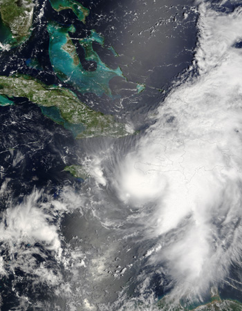
Click image to enlarge.
Tropical Storm Ernesto has been a difficult storm to forecast. Now, Ernesto is leaning a little more to the east, which will save northern Florida from a direct overpass of Ernesto's eye later this week, as he is expected to exit the Florida east coast just south of Cocoa Beach on Wed. morning, Aug. 30.
As of the 2:00 p.m. EDT report of Aug. 28, The National Hurricane Center forecasts Ernesto to make landfall in southern Florida, to the east of the Florida Keys, and closer to Homestead, Fla. and Biscayne National Park early morning on Wed. Aug. 30.
Currently, Ernesto is still bringing heavy rains to eastern Cuba. At 2:00 p.m. EDT the poorly-defined center of Tropical Storm Ernesto was estimated near latitude 20.7 north and longitude 76.1 west or about 15 miles east-southeast of Holguin, Cuba. Ernesto is moving toward the northwest near 10 mph, and is expected to continue moving north for the next 24 hours. Ernesto should come off the north coast of Cuba later today. Maximum sustained winds are near 40 mph, and Ernesto is forecast to re-strengthen tonight. Estimated minimum central pressure is 1007 millibars.
This photo-like image was acquired by the Moderate Resolution Imaging Spectroradiometer (MODIS) on the Terra satellite on August 27, 2006, at 11:50 a.m. local time (15:50 UTC). At the time of this image, Hurricane Ernesto was a well-developed storm system, but its interactions with Hispaniola had started to distort the hurricane enough to rob it of a well-defined eye. According to the University of Hawaii’s Tropical Storm information center, Ernesto had sustained peak winds of around 110 kilometers per hour (65 miles per hour) at the time Aqua MODIS acquired these data. Credit: NASA/Jeff Schmaltz, MODIS Rapid Response Team
CloudSat Watches Tropical Storm Ernesto Head to Florida
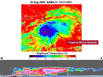 Click image to enlarge.
These two images are from two different satellites, giving a top-down and sideways view of Tropical Storm Ernesto, spinning in the Caribbean on Aug. 26, 2006. Ernesto as of Aug. 28 at 8 a.m. EDT was on a track toward Florida.
The top image is from the National Oceanic and Atmospheric Administration's Geostationary Operational Environmental Satellite (GOES) to give an idea of how the storm looked from the top. This data was processed by NASA's GOES Project at the Goddard Space Flight Center, Greenbelt, Md. The bottom images are from CloudSat.
The CloudSat image (bottom) was taken from NASA's CloudSat satellite on Aug. 26. The right side of the CloudSat image shows less cloud cover, which matches with the top left part of the storm in the GOES image above.
The red and purple areas on the CloudSat image (bottom) indicate large amounts of cloud water. The blue areas along the top of the clouds indicate cloud ice, while the wavy blue lines on the bottom center of the image indicate intense rainfall. Notice that the solid line along the bottom of the panel, which is the ground, disappears in these areas of intense precipitation. It is likely that in the area the precipitation rate exceeds 30mm/hr (1.18 inches/hour) based on previous studies.
Where is Ernesto Going?
The National Hurricane Center (NHC) forecast for Ernesto takes him out of southeast Cuba and through the Florida Everglades, and traveling along the Florida east coast, remaining over land until late Thurs. Aug. 31. By Sat. Sept. 2, Ernesto is projected to be just east of the Virginia/North Carolina border at sea.
Hurricane Watches For Parts of Florida
A hurricane watch remains in effect for the southern peninsula of Florida from Deerfield Beach southward on the east coast and from south of Chokoloskee southward along the west coast. A hurricane watch remains in effect for all of the Florida Keys from ocean reef to the Dry Tortugas. A hurricane watch is also in effect for Andros Island in the northwestern Bahamas. A hurricane watch means that hurricane conditions are possible within the watch area generally within 36 hours. Additional hurricane watches may be required for portions of the Florida peninsula later today.
Where is Ernesto on Mon. Aug. 28?
At 8:00 a.m. EDT, Ernesto was located near latitude 19.9 north, longitude 75.5 west, on the coast of southeastern Cuba about 20 miles west of Guantanamo. Ernesto is moving toward the northwest near 12 mph, and will possibly emerge off the northern coast of Cuba later tonight or Tues. morning, Aug. 29 Maximum sustained winds have decreased to near 45 mph and additional weakening is likely as Ernesto moves over land today. The estimated minimum central pressure is 1005 millibars.
Ernesto's Visit to Cuba
According to the National Hurricane Center, Ernesto made landfall on Cuba's southeast coast as a tropical storm Mon. Aug. 28. Heavy rains were reported at Guantanamo, Cuba. As of 8:00 a.m. EDT Ernesto was bringing flooding rains over southeast Cuba. A hurricane warning remains in effect for the Cuban provinces of Guantanamo, Santiago de Cuba, Granma, Holguin, Las Tunas, and Camaguey. A tropical storm warning is in effect for ragged island and great Exuma in the central Bahamas.
Rainfall amounts of 6 to 12 inches with possible isolated amounts of up to 20 inches are expected over portions of Hispaniola and Central and eastern Cuba. These rains could cause life-threatening flash floods and mud slides. Rainfall amounts of 2 to 4 inches are possible across the southern Bahamas. For updates on Ernesto's forecast track go to the + National Hurricane Center
+ More on Ernesto Credit: NASA GOES PROJECT -- Caption: Rob Gutro, NASA/GSFC from NHC reports
Tropical Storm Ernesto Named in the Caribbean, Headed to the Gulf
At 4:00 p.m. EDT, on Fri. Aug. 25, Tropical Depression Five became Tropical Storm Ernesto, according to the National Hurricane Center. Jamaica and Haiti issued tropical storm watches as Ernesto was approaching.
At 5:00 p.m. EDT the center of Tropical Storm Ernesto was located near latitude 14.3 north and longitude 67.6 west or about 300 miles south-southwest of San Juan, Puerto Rico and about 660 miles east-southeast of Kingston, Jamaica.
Ernesto is moving toward the west-northwest near 16 mph and this general motion is expected to continue for the next 24 hours. Maximum sustained winds are near 40 mph with higher gusts. Additional strengthening is possible during the next 24 hours. The latest minimum central pressure reported by an air force reserve hurricane hunter aircraft is 1004 millibars.
Rainfall amounts of 3 to 6 inches are expected in association with Ernesto across portions of Hispaniola and Jamaica, with 1-3 inches expected for parts of Puerto Rico and the Dutch Netherland Antilles. For updates on Ernesto's forecast track go to the + National Hurricane Center
All Eyes in the U.S. Watching Tropical Depression #5
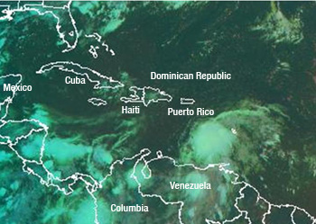
Click image to enlarge.
The fifth tropical depression of the season formed in the Caribbean on Aug. 24, and forecasters in the U.S. are watching it carefully.
The National Hurricane Center (NHC) forecast for Tropical Depression (TD) #5 as of 11:00 a.m. EDT (15:00 UTC) on Aug. 25, places TD#5's center near 13.9 North and 66.4 West. It's about 340 miles south of San Juan, Puerto Rico, and 760 miles east-southeast of Kingston, Jamaica. People in Jamaica and the Cayman Islands should monitor the progress of this depression.TD #5's movement is toward the west-northwest near 15 mph, estimated minimum central pressure is 1005 millibars, and maximum sustained winds are near 35 mph. Some strengthening is expected, and TD#5 could become Tropical Storm Ernesto later on Friday, Aug. 25.
TD #5 can be seen in this satellite image from the National Oceanic and Atmospheric Administration's Geostationary Operational Environmental Satellite (GOES). This data was processed by NASA's GOES Project at the Goddard Space Flight Center, Greenbelt, Md. TD#5 is the white circle of clouds in the bottom right corner of the image, located north of Venezuela, and west of the Lesser Antilles islands.
What's in Store for TD#5?
At 11:00 a.m. EDT (1500 UTC), Aug. 25, the NHC's new intensity forecast calls for the cyclone to become a hurricane in about 72 hours (by Mon. Aug. 28). However, if the wind shear decreases as much as forecast, the cyclone could be significantly stronger than currently forecast after 72 hours. The forecast track as of 11:00 a.m. on Friday, Aug. 25 projects the storm on a west-northwest path and due south of central Cuba by early Monday morning, Aug. 28. Credit: NASA GOES PROJECT -- Caption: Rob Gutro, NASA/GSFC from NHC reports