
- NASA Home
- | Centers
- | Dryden Home
- | News
- | X-Press
- | Stories
- | 2006
Search Dryden
Feature
Earth Science:
Dryden Capabilities Contribute
to Demonstration Missions
Dryden Capabilities Contribute
to Demonstration Missions
July 31, 2006
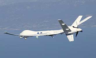
Image above: General Atomics Aeronautical Systems' uninhabited Altair will begin a series of missions in August to prove the utility of unmanned air systems in carrying instruments to help field commanders gather information for use in battling summer wildfires in western states.
NASA photo by Carla Thomas
The Western States Unmanned Aircraft Systems Fire Mission is scheduled to begin Aug. 14, with Dryden and Ames Research Center, Moffett Field, Calif., assisting the U.S. Forest Service, said Robert Navarro, Dryden's Altair project manager.
The Altair, leased by Dryden from General Atomics Aeronautical Systems Inc., San Diego, will fly at altitudes of about 43,000 feet during missions, which will originate from the General Atomics facility at Gray Butte, Calif.
"Altair is carrying an instrument that will penetrate smoke and ash and transmit the imagery down to a station on the ground," explained Navarro, referring to the Autonomous Modular System, which uses multi-spectral line scanning that utilizes thermal channels.
"The images will be available to the fire commander, in near-real time, and will show the fire's hot spots to help efficiently use resources on the ground to knock down the flames."
In addition, software in the ground mission planning system will superimpose road maps and other valuable information in near-real time to assist firefighters in seeing not only where hot spots are but also the best ways to reach them.
Altair research flights could include missions to Northern California, Washington, Oregon, Idaho, Utah, Arizona or "wherever the fire is," Navarro said.
Instrumentation on the Altair also includes a National Oceanic and Atmospheric Administration atmospheric gas-sampling tool.
Providing the tools
Altair is one of several Dryden research tools available to aid the Earth science community, said Bob Curry, acting director of Dryden's Science mission directorate, of which Dryden's work for the Earth Science Capability Demonstration is a part. Key aircraft assets such as the ER-2 and Altair as well as a Predator-class uninhabited air system, or UAS, that Dryden expects to acquire will be available for customer needs on airborne projects.

Image above: The ER-2 is one of many assets available through the Dryden Science mission directorate for customers with research needs in the upper atmosphere. Dryden also is working to add new capabilities to its aircraft to accommodate new customers.
NASA photo by Tony Landis
The Suborbital Office at NASA Headquarters provides Earth science researchers with access to Dryden's resources in areas such as atmospheric science, geology and land use for work involving such global problems as climate change and international pollution, Curry said. In addition to preparing new UAS platforms for science missions, he said Dryden is working to reacquaint the science community with the ER-2's utility and reliability. He'd like to see the ER-2 busy year-round for science missions again, as it was in the 1990s.
"The ER-2 is a highly unique airplane with complex, one-of-a-kind capabilities," Curry said. "Our contribution is to be able to provide airborne flight services reliably and to meet mission objectives within budget and on schedule."
Reliability in systems and research platforms is critical for scientists researching specific phenomena such as weather and geologic events occurring at certain locations and times of the year, he said.
"We've been asked to pursue the use of unpiloted air vehicles to help the Earth science community get their instruments aloft in different kinds of scenarios that just are not possible in piloted aircraft. Endurance - being able to fly for 24 hours or more - is just one scenario that is unique to the unpiloted aircraft," said Frank Cutler, Dryden's Earth Science Capability Demonstration project manager.
Another is the very hazardous scenario in which it would not be worth the risk to deploy piloted aircraft. A mission is planned for this hurricane season, for example, wherein a small UAS will be flown at low altitudes in a hurricane to collect data never before available to weather modelers.
Developing new capabilities
In addition to research platforms and currently available technology, Dryden is helping to develop new technology enhancements for unpiloted aircraft that could present new possibilities.
Structural and navigational modifications are underway on the NASA G III aircraft for carrying new synthetic aperture radar. This new system will be capable of being flown repeatedly over any period of time through a predetermined 10-meter "tube" in the airspace, allowing researchers to detect and analyze minute changes in the Earth's crust, Cutler said.
This new capability, called the Repeat Pass Interferometry (a part of the UAV synthetic aperture radar, or UAVSAR) - may eventually be incorporated into a UAS platform. The new system could be especially useful, for example, to researchers investigating seismic fault lines. The Jet Propulsion Laboratory, Pasadena, Calif., is at work on the instrument and related data analysis tools while Dryden is developing the precision navigation system, structurally modifying the aircraft and designing pods to carry the UAVSAR instrument.
Adding this new technology to piloted aircraft like the G III is an efficient means of moving these technologies to UAS platforms, Cutler said. The UAVSAR ultimately could be transferred to a Predator-class aircraft. Developers of the system believe it can be refined even further to navigate the aircraft using the tool inside a one-meter tube, providing researchers with an even higher-resolution means of studying Earth's ever-changing crust.
New data system
When Altair flies in August it will feature Dryden innovations like the Research Environment for Vehicle-Embedded Analysis on Linux capability, or REVEAL, a programmable gateway between onboard instruments and wireless communication paths to and from the aircraft.
In a nutshell, this new data system allows for high-tech, real-time capture and transfer of information from instruments onboard the aircraft to users or researchers on the ground. Information from the aircraft then can be enhanced with overlays such as digital weather and terrain maps to give researchers broad situational awareness of the environment within which the instruments are operating.
"We're working with the researchers to help them get their instruments on the appropriate aircraft platform," Cutler explained. "We offer to bring them onsite to look at the aircraft and understand what we're doing with it. Once we think we have a mission, we look to see what instruments group together to allow researchers to share costs to make it more affordable."
Building relationships
Dryden has a long history of working with UAS aircraft, excellent relationships with other test ranges and a thorough understanding of how to work with the Federal Aviation Administration, Cutler said.
"The FAA trusts us to do the right thing. If it were not safe, our own agency wouldn't allow it. They're banking on our reputation. Our safety-review processes are very important," he said. "The UAS activities of Dryden and its partners will undoubtedly help to shape how UAS operations become routine in the national airspace."
The FAA is currently undergoing reorganization aimed in part at setting up airframe certification and flight authorization procedures for UAS vehicles, Cutler said. Large-scale civil operations of UAS are complicated and will require time and patience to be safely developed, he added.
Further assessment
In the meantime, UAS capability assessment studies are ongoing to identify the types of technologies required to fulfill requirements and whether those technologies are available or will need to be developed, Cutler continued.
The Suborbital Science office at NASA Headquarters is Dryden's key customer, he said, and he anticipates a long and productive relationship that will evolve into exciting UAS science missions.
"We're currently assessing the possibility of UAS participation in the International Polar Year activities that are due to start in about a year," he said. The proposed polar mission would entail long-duration flights as well as the need to land on icy runways and cope with extreme weather conditions that constantly and quickly change.
"Can these systems operate in unforgiving environments?" Cutler asked.
That's part of the mission - determining the best way to get it accomplished.
Altair is seen as one of the center's workhorse UAS aircraft for science missions. It successfully completed an 18.4-hour NOAA project in November 2005, a high-altitude, long-endurance series of missions that entailed collection of airsamples at various altitudes, missions 800 miles off the U.S. West Coast, enforcement patrol, use of high-resolution digital cameras for mapping, monitoring coastline erosion and counting coastal sea mammal populations.
"Information that UAS aircraft can help researchers gather will help to develop better models to predict what will happen next," Cutler said.
X-Press Editor