
|
|

 Entry
Entry
Island of Hawai`i Lava-flow Hazard Zones |
Maps showing volcanic hazard zones on the island of Hawai`i were first prepared in 1974 by Donal Mullineaux and Donald Peterson of the U.S. Geological Survey and were revised in 1987. The current map (simplified version appears below) divides the island into zones that are ranked from 1 through 9 (table of hazard-zone descriptions) based on the probability of coverage by lava flows. Other direct hazards from eruptions, such as tephra fallout and ground cracking and settling, are not specifically considered on this map; however, these hazards also tend to be greatest in the areas of highest hazard from lava flows.
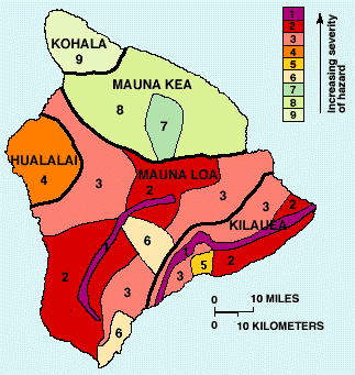
Hazard zones from lava flows are based chiefly on the location and frequency of both historic and prehistoric eruptions. Historic eruptions" include those for which there are written records, beginning in the early 1800's, and those that are known from the oral traditions of the Hawaiians. Our knowledge of prehistoric eruptions is based on geologic mapping and dating of the old flows of each volcano. The hazard zones also take into account the larger topographic features of the volcanoes that will affect the distribution of lava flows. Finally, any hazard assessment is based on the assumption that future eruptions will be similar to those in the past.
More detailed information about lava flow hazard zones can be found in Volcanic and Seismic Hazards on the Island of Hawai`i and the map reference below.
![]() Using Google Earth to determine Lava Flow Hazard Zones for Hawai`i County. This Volcano Watch Article announces the release of the first Google Earth mapping file made available by HVO: one that displays Lava Flow Hazard Zones for the County of Hawai`i on the Google Earth base. If you can find your house or even your neighborhood on Google Earth, you�ll be able to use this overlay to see what Lava Flow Hazard Zone you are in. Install
Using Google Earth to determine Lava Flow Hazard Zones for Hawai`i County. This Volcano Watch Article announces the release of the first Google Earth mapping file made available by HVO: one that displays Lava Flow Hazard Zones for the County of Hawai`i on the Google Earth base. If you can find your house or even your neighborhood on Google Earth, you�ll be able to use this overlay to see what Lava Flow Hazard Zone you are in. Install ![]() if you haven�t already done so and click on http://hvo.wr.usgs.gov/hazards/lavazones/HVO_LavaFlowHazardZones.kmz
to view the Lava Flow Hazard Zones for Hawai`i County.
if you haven�t already done so and click on http://hvo.wr.usgs.gov/hazards/lavazones/HVO_LavaFlowHazardZones.kmz
to view the Lava Flow Hazard Zones for Hawai`i County.
Reference
Wright, T.L., Chu, J.Y., Esposo, J., Heliker, C., Hodge, J., Lockwood, J.P., and Vogt, S.M., 1992, Map showing lava-flow hazard zones, island of Hawaii: U.S. Geological Survey Miscellaneous Field Studies Map MF-2193, text 1 p., scale 1:250,000.
![]()
![]()
![]()
![]()
![]()

![]()
![]()
![]()
![]()
Contact: hvowebmaster@usgs.gov
Updated: 30 October 2006 (pnf)