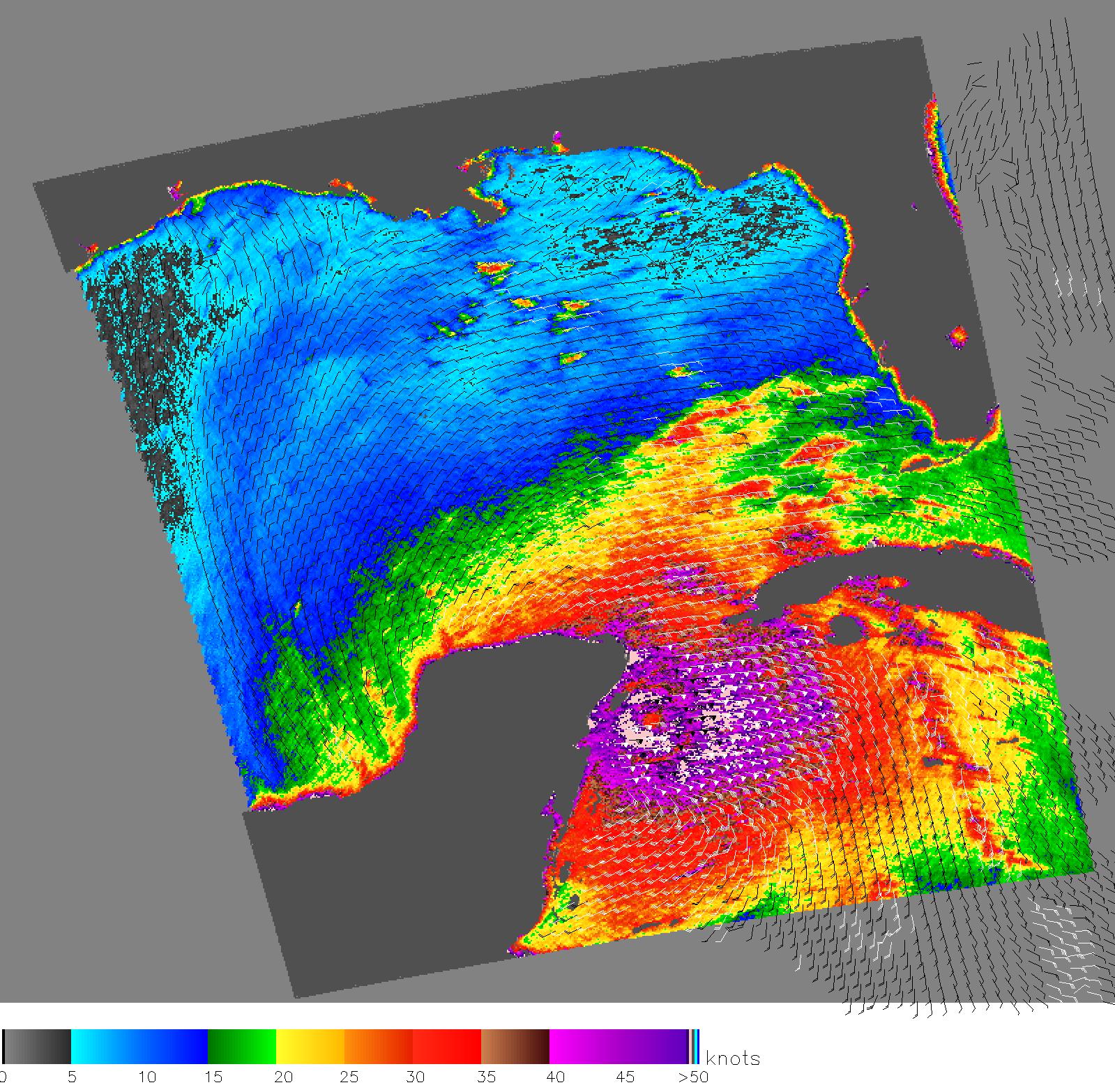
The eye of Hurricane Wilma, a menacing Category 4 storm, approaches the
northeastern tip of Mexico's Yucatan Peninsula in this October 21 image
from NASA's QuikScat satellite, depicting relative wind speeds and
direction. The storm is projected to make landfall in south Florida on
Monday.
Ground measurements of the wind strength of Hurricane Wilma show sustained
winds somewhat higher than those shown by QuikScat observations. This is
because the power of the storm makes accurate measurements difficult. The
scatterometer sends pulses of microwave energy through the atmosphere to
the ocean surface, and measures the energy that bounces back from the
wind-roughened surface. The energy of the microwave pulses changes
depending on wind speed and direction, giving scientists a way to monitor
wind around the world.
Tropical cyclones (the generic term for hurricanes and typhoons), however,
are difficult to measure. To relate the radar energy return to actual wind
speed, scientists compare measurements taken from buoys and other ground
stations to data the satellite acquired at the same time and place.
Because the high wind speeds generated by cyclones are rare, scientists
do not have corresponding ground information to know how to translate
data from the satellite for wind speeds above 50 knots (about 93 km/hr or
58 mph). Also, the unusually heavy rain found in a cyclone distorts the
microwave pulses in a number of ways, making a conversion to accurate wind
speed difficult. Instead, the scatterometer provides a nice picture of the
relative wind speeds within the storm and shows wind direction.
For more information about the storm, please visit the National Hurricane Center.
QuikScat Background
NASA's Quick Scatterometer (QuikScat) spacecraft was launched from
Vandenberg Air Force Base, California on June 19, 1999. QuikScat carries
the SeaWinds scatterometer, a specialized microwave radar that measures
near-surface wind speed and direction under all weather and cloud
conditions over the Earth's oceans. More information about the QuikScat
mission and observations is available at http://winds.jpl.nasa.gov.
QuikScat is managed for NASA's Science Mission Directorate, Washington,
DC, by NASA's Jet Propulsion Laboratory, Pasadena, CA. JPL also built the
SeaWinds radar instrument and is providing ground science processing
systems. NASA's Goddard Space Flight Center, Greenbelt, MD, managed
development of the satellite, designed and built by Ball Aerospace &
Technologies Corp., Boulder, CO. The National Oceanic and Atmospheric
Administration has contributed support to ground systems processing and
related activities.


