|
Rango's main task these days is predicting how much water the Rio
Grande will deliver to the desert, particularly to farmers who use the
river to irrigate. Farmers around the Jornada grow mainly chili peppers,
cotton, and pecans. Farther north, farmers use older, smaller irrigation
systems to grow tomatoes and other high-value crops.
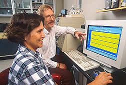
Rango works with NRCS and the Bureau of Reclamation to research ways
to predict the Rio Grande's streamflow. He has been predicting daily
flow of the river at Del Norte, Colorado, for the past 3 years. He usually
does forecasts for April through September, to cover the growing season.
He checks the predictions with actual streamflow measured daily at Del
Norte.
Rango does these predictions using the Snowmelt Runoff Model (SRM),
which he developed in the 1970s. Ironically, Rango first tested the
SRM on the Rio Grande in the late 1970s while stationed at ARS's Beltsville
(Maryland) Agricultural Research Center. The runoff model is used together
with sensors positioned throughout the West to measure snowpack.
Once streamflow predictions become operational, farmers will use them
to decide which and how many crops to plant each year. They will also
be used by NRCS, the U.S. Army Corps of Engineers, state engineers'
offices, and others in managing these water resources.
In 2001, when the National Aeronautics and Space Administration launched
the Terra satellite with the new MODIS (Moderate Resolution Imaging
Spectroradiometer) sensor, Rango and colleagues began using this imagery
of snow-covered parts of the Chihuahuan Desert and mountain snowpacks
in Colorado and New Mexico. Later, NASA launched a complementary satellite,
Aqua, which also supplies data to Rango. The MODIS sensors give a higher
resolution than satellite imagery he had been using.
Rango also contributes his remote-sensing expertise to other areas
of Jornada research, including the monitoring of rangeland health and
controlling of livestock grazing.
Monitoring Rangeland Now
ARS soil scientist Jeff Herrick and colleagues led the effort to develop
an improved rangeland-monitoring manual for field use. It contains instructions
for various soil and vegetation measurements and forms for ranchers
and land managers to record data. "It provides a way to gather
data needed to support rangeland assessments done with the guidelines
that were first issued in 1999," Herrick says.
Herrick co-authored those earlier assessment guidelines along with
representatives of the U.S. Geological Survey, NRCS, and the Bureau
of Land Management (BLM). These are now in use widely in the United
States, and the Mexican government has translated them into Spanish.
"This is one of the biggest impacts we have had," he says.
Herrick is working with ARS ecologist Brandon Bestelmeyer, who is doing
ecological descriptions of Southwestern rangelands based on research
at the Jornada. Together they are integrating monitoring and assessment
tools with the ecological models Bestelmeyer works with. They are collaborating
with the U.S. Department of Defense, NRCS, BLM, and the National Park
Service.
The models Bestelmeyer works on are called "state and transition"
models because they predict how broad areas of land might change under
various management practices. So far, he has created or contributed
to models that will work for much of New Mexico, Arizona, Utah, and
Texas. They can help everyone from ranchers to government personnel
in interpreting data on their land to make land-management decisions.
Bestelmeyer is working with Peters and ARS range ecologist Sandy Tartowksi
to describe how ecological drivers at different scales are changing
vegetation. Their data feed into both ECOTONE and the state and transition
models.
Bestelmeyer says, "Historical data shows us that vegetation reaches
a threshold point, a critical stage beyond which the change is irreversible.
Here, that's usually grassland being replaced by shrubs. Different pressures,
such as overgrazing or drought, can push land over the threshold. We
want to predict when that threshold will be reached, so we can avoid
it."
Virtual Cattle Herding
Animal scientist Dean M. Anderson has a vision of how to reduce grazing
pressure by fencing sheep, cows, and other animals with Directional
Virtual Fencing (DVF™), an invisible electronic fence similar to
that sometimes used to control dogs. Anderson patented the concept in
collaboration with Craig S. Hale of Future Segue, a private electronics
firm in Las Cruces.
"This tool combines electronic technology with animal behavior
and knowledge of animal and plant biology to control livestock movement
in a humane way," Anderson says.
With it, cows would cross their large desert pastures, guided by Global
Positioning System technology, to locations where forage is available
and suitable for grazing. They would keep returning to a watering hole
where they would get "marching orders" from satellites. Computer
nodes at the watering hole would download the cows' meandering data
and send it back for analysis of grazing patterns.
DVF data is stored in an electronics package similar in size to a deck
of playing cards. The current version of the device is worn on a neck
collar that sends cues to ear tags to steer the cows to water or fresh
grass. When the cows are first learning their boundaries, they get an
audio cue or a mild electric shock similar to that used on dogs.
Anderson has proven the concept works by testing prototypes on three
cows and using them to move a small herd around. By the end of 2004,
he expects to have many more prototypes built to conduct larger-scale
tests."We're right on the verge of commercializing this device,"
he says.
Rango is helping Anderson find ways to eventually link with satellites
that would locate desirable grazing areas for livestock.
The End of Range Wars
Tartowski, who is working to develop new remediation technologies,
has high hopes for Anderson's research. She knows from the ranchers
and land managers she works with how much they would like to do away
with traditional fences.
"It's a major cost to build and maintain fences," she says.
"And they're not always placed in the areas that make the most
sense in terms of rainfall patterns or animal management."
The main thing that impresses Tartowski about DVF technology is that
it changes the perception of livestock from being a land problem to
a land-improvement tool that can help shape the landscape in a desirable
way. Virtual fencing—like much of the Jornada research—can
help slow desertification or even stop it in some cases, because it
promises an economical way to keep cattle properly distributed across
the range.
Research at the Jornada is all about judiciously nudging natural ecosystem
processes to improve land health while supporting sustainable human
use. More than a century's experience with a landscape that still bears
the scars of natural assaults on vegetation and misuse from the days
of the Old West provides an ideal laboratory for meeting these needs.
Furthermore, tools like the ECOTONE model allow scientists to make better
use of this historical data to forecast future dynamics.
The Jornada scientists are helping build a database for rangeland management
that has significance for the one-third of the Earth's land mass that
is desert—an area that is increasing all the time.—By Don
Comis, Agricultural Research Service Information Staff.
This research is part of Rangeland, Pasture, and Forages, an ARS
National Program (#205) described on the World Wide Web at www.nps.ars.usda.gov.
To reach scientists mentioned in this article, contact Don
Comis, USDA-ARS Information
Staff, 5601 Sunnyside Ave., Beltsville, MD 20705-5129; phone (301)
504-1625, fax (301) 504-1641.
"A River Runs Through It: The Jornada Experimental Range Battles
Desertification" was published in the July
2004 issue of Agricultural Research magazine.
|