- Original Caption Released with Image:
-
 |
 |
| Figure 1 |
Movie |
This 3-D anaglyph image of Mt. St. Helens volcano combines the
nadir-looking and back-looking band 3 images of ASTER. To view the image
in stereo, you will need blue-red glasses. Make sure to look through the
red lens with your left eye.
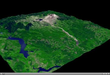
Figure 1: This ASTER image of Mt. St. Helens volcano in Washington was
acquired on August 8, 2000 and covers an area of 37 by 51 km. Mount Saint
Helens, a volcano in the Cascade Range of southwestern Washington that had
been dormant since 1857, began to show signs of renewed activity in early
1980. On 18 May 1980, it erupted with such violence that the top of the
mountain was blown off, spewing a cloud of ash and gases that rose to an
altitude of 19 kilometers. The blast killed about 60 people and destroyed
all life in an area of some 180 square kilometers (some 70 square miles),
while a much larger area was covered with ash and debris. It continues to
spit forth ash and steam intermittently. As a result of the eruption, the
mountain's elevation decreased from 2,950 meters to 2,549 meters. The
image is centered at 46.2 degrees north latitude, 122.2 degrees west
longitude.
Movie: The simulated fly-over was produced by draping ASTER visible and
near infrared image data over a digital topography model, created from
ASTER's 3-D stereo bands. The color was computer enhanced to create a
natural color image, where the vegetation appears green. The topography
has been exaggerated 2 times to enhance the appearance of the relief.
The U.S. science team is located at NASA's Jet Propulsion Laboratory,
Pasadena, Calif. The Terra mission is part of NASA's Science Mission
Directorate.
- Image Credit:
-
NASA/GSFC/METI/ERSDAC/JAROS, and U.S./Japan ASTER Science Team
|


