

As the storm shifts eastward, Washington, northern Oregon, northern Idaho and northwest Montana will get a break from flooding rain and rapid snow melt. Rivers should rapidly lower to below flood stage.
Snow will continue from Montana to Utah and Colorado with lingering gusty winds in the Front Range.
Moderate Santa Ana winds will pick up over Southern California and last through the weekend.
Highs Friday will range from the single digits and teens in eastern Montana to the 40s west of the Cascades to the 60s and 70s in the Southwest.
The West will be quiet Saturday except for a few Washington sprinkles and flurries. Winds will be gusty in the Chinook zone of Montana.
On Sunday, a storm passing by to the north across Canada will bring a few showers and snow showers to Washington and light snow to northern Idaho, Montana and northern Wyoming.
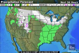
As the once Northwest storm zips eastward across the Midwest, a swath of 3-to-6-inch snow (a few spots could possibly be higher) will fall from the Dakotas to the southern Great Lakes, including Minneapolis, Madison, Milwaukee and Chicago.
Just south of the snow, sleet and some freezing rain are possible from Iowa to central Indiana.
A few showers will develop later in the day ahead of the cold front in the mid-Mississippi and lower Ohio Valleys.
Highs Friday will range from the single digits and teens in North Dakota to the low and middle 50s in much of Kansas and Missouri.
On Saturday, the snow, wintry mix and rain will gradually exit from the southern Great Lakes and Ohio Valley into the Northeast.
On Sunday and Monday, two Canadian disturbances will dip southward through the region with mainly light snow and more cold air.
A new clipper low-pressure system will zip from the Dakotas into the Ohio Valley Tuesday. An arctic cold front will follow this clipper bringing more frigidly cold air into the Plains and Midwest. Highs Tuesday will be well below zero across Minnesota and much of North Dakota and Wisconsin.
A few snow showers and weakening lake effect will continue from Pennsylvania to Maine, but much of the Northeast will have a dry Friday.
High temperatures will range from the teens in northern New York and northern New England to the 40s in southern Virginia.
On Saturday and Saturday night, the Midwest storm will track across the Mid-Atlantic with snow across northern Pennsylvania, northern New Jersey, southern and central New York and southern New England. Some locations could see over 6 inches of snow.
South of the snow on Saturday, wintry mix and freezing rain will hit southern Pennsylvania, southern New Jersey, northern West Virginia, the northwest suburbs of Washington, northern Maryland, and northern Delaware. Rain will fall across the remainder of Virginia.
The exiting storm could linger snow over New England early Sunday.
Monday and Tuesday, two disturbances, one through the St. Lawrence Valley and another through the southern Mid-Atlantic, will bring some snow to the region.
Another quick moving system will bring more snow to the Northeast Wednesday, followed by arctic air.
The South will be almost rain free Friday, except for a few afternoon showers ahead of a cold front in Arkansas.
Highs Friday will range from the 40s in North Carolinas to the low 80s in south Texas.
The showery cold front will sweep from the lower Mississippi Valley to the Southeast Coast Saturday. Highs Saturday will range from the 40s in northern Texas, Oklahoma, Arkansas and Tennessee to the 70s in Florida.
On Sunday the South will be dry again except for a few exiting showers in Florida.
Monday will be rain free.
An arctic cold front will move into the South Wednesday setting the stage for possible snow or wintry mix from the Ark-La-Tex to the Carolinas next Thursday into Friday.