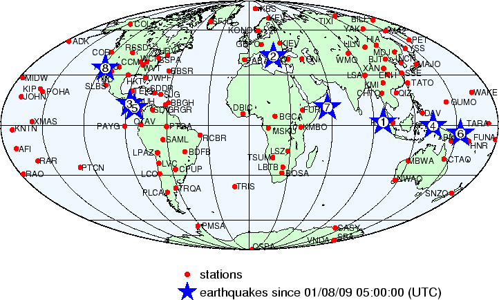
The red dots on this map indicate seismograph stations which are transmitting their data live, via the Internet, to the Albuquerque Seismological Laboratory. You can see these live data (in plots which automatically update every 30 minutes) on our Seismic Data Page.
The following earthquakes are plotted on the map above:
| earthquake number |
DATE yy/mm/dd | TIME (GMT) hh:mm:ss |
LAT degrees | LON degrees | DEP km |
MAG | Q | COMMENTS |
|---|---|---|---|---|---|---|---|---|
| 1 | 09/01/08 | 11:40:43 | 1.80N | 96.70E | 10.0 | 5.0M | A | NIAS REGION, INDONESIA |
| 2 | 09/01/08 | 12:04:05 | 41.77N | 20.80E | 10.0 | 4.9M | A | MACEDONIA |
| 3 | 09/01/08 | 12:31:43 | 12.58N | 87.86W | 69.5 | 4.6M | B | NEAR COAST OF NICARAGUA |
| 4 | 09/01/08 | 16:18:49 | 0.41S | 132.88E | 10.0 | 5.4M | A | NEAR N COAST OF PAPUA, INDONESIA |
| 5 | 09/01/08 | 19:21:34 | 10.20N | 84.16W | 4.5 | 6.1M | ||
| 6 | 09/01/08 | 21:47:06 | 4.93S | 153.02E | 80.8 | 5.1M | B | NEW IRELAND REGION, P.N.G. |
| 7 | 09/01/09 | 03:44:39 | 10.51N | 56.97E | 10.0 | 5.5M | CARLSBERG RIDGE | |
| 8 | 09/01/09 | 03:49:46 | 34.11N | 117.29W | 13.8 | 4.5M |
The earthquake information presented here is from the USGS National Earthquake Information Center. You are encouraged to visit the Earthquake Hazards Program website for more detailed information on recent or historical earthquakes, maps, etc.