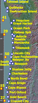
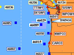
Skip Navigation Linkswww.weather.gov 
NOAA logo - Click to go to the NOAA homepage National Weather Service Forecast Office   NWS logo - Click to go to the NWS homepage    
Portland, Oregon
navigation bar decoration    
 
 
Current Warnings


Current Conditions


Forecasts


Experimental...


Climate...


Model Data


Weather Safety


Miscellaneous


Contact Us


Marionberries Pacific Waves Yaquina Lighthouse on Oregon Coast Fall in Oregon
Marine Forecasts

Pacific NW Coastal Marine Data

Local Marine Weather News...
    flashing new item    Need More Detail? Try our Mariner's Weather Matrix. This will give detailed wind, seas, and other critical weather data for mariners in an easy-to-read table.
    noaa icon  NOAA's National Marine Forecasts page
    noaa icon    Dial-A-Buoy (888-701-8992)
Mariner's Weather Matrix
Marine Matrix

Forecasts &
Conditions
Buoys &
Coast Winds
Seas/Waves
Forecasts
Sea Surface Temperatures Tides
Coastal Wind Stations Local & Regional Buoys
Coastal Winds
For more detailed wind data, see our MesoWest page.
Clatsop Spit Siuslaw Jetty Cape Blanco Port Orford Charleston Newport airport South Beach Gold Beach Cape Arago Newport Jetty Cape Foulweather Lincoln City Tillamook Manzanita Seaside Ocean Park Port Orford, Buoy 46027 Port Orford, Buoy 46015 Stonewall Bank or Yaquina, Buoy 46050 Columbia River, Buoy 46029 Cape Elizabeth, Buoy 46041 Crescent City airport North Bend airport Astoria airport Hoquiam airport Grays Harbor buoy Destruction Island Quilliyute airport Tatoosh Island This image map shows the locations of buoys along the Pacific Northwest coast..
WA Coast...
  • Destruction Isl.
  • Grays Harbor
  • Hoquiam
  • Ocean Park


  • N Oregon Coast
  • Clatsop Spit
  • Astoria
  • Seaside
  • Manzanita
  • Tillamook
  • Garibaldi
  • Lincoln City
  • Cape Foulweather
  • Newport Jetty
  • Newport Airport
  • South Beach
  • Siuslaw Jetty
  • Dunes (RAWs)


  • S Oregon Coast
  • Cape Arago
  • Cape Blanco
  • Port Orford
  • Gold Beach
  • This image map shows the locations of buoys along the Pacific Northwest coast. Tillamook Columbia River Desdemona Light near Bellingham Smith Island Point St George Port Orford West Point Smith Island Cape Arago 46006 46002 StonewallBank/Yaquina Bay Newport Jetty 46005 46036 Destruction Island Tatoosh Island Cape Elizabeth Vancouver Island .
    Oregon Nearshore
  • DMNO3 ( Desdemona Light )
  • 46029 ( Columbia River )
  • MLTO3 ( Marsh Island )
  • 46089 ( Tillamook )
  • 46050 ( Yaquina Bay )
  • NWPO3 ( Newport Bay )
  • SBEO3 ( South Beach )
  • CHAO3 ( Charleston )
  • 46015 ( Port Orford )
  • PORO3 ( Port Orford )
  • CARO3 ( Cape Arago )
  • 46027 ( Pt St George )

    Washington Nearshore
  • # 46206 ( Vancouver Isl. )
  • # TTIW1 ( Tatoosh Isl. )
  • # DESW1 ( Destruction Isl. )
  • # TOKW1 ( Toke Point. )
  • # 46211 ( Grays Harbor. )
  • # 46041 ( Cape Elizabeth )

  • Offshore Buoys
  • 46005 | 46002 | 46006
  • 46036 | 46004 | 46059


    1. Miscellaneous Items:
    2. Other Bouy's Data, including historical data from buoys.
    3. NOAA's Ocean Prediction Center, with lots of marine data from around the world
    4. Canadian Coastal Marine Weather & Forecasts
    5. NOAA's Daily Weather Maps, including archived maps
    6. Point Reyes Radio-Fax Schedule


    Webmaster
    US Dept of Commerce
    National Oceanic and Atmospheric Administration
    National Weather Service
    Portland Weather Forecast Office
    5241 NE 122nd Avenue
    Portland, OR 97230-1089

    Tel: (503) 261-9246

    Disclaimer
    Information Quality
    Credits
    Glossary
    Privacy Policy
    Freedom of Information Act
    About Us
    Career Opportunities

    National Weather Service Mission: "The National Weather Service (NWS) provides weather, hydrologic, and climate forecasts and warnings for the United States, its territories, adjacent waters and ocean areas, for the protection of life and property and the enhancement of the national economy. NWS data and products form a national information database and infrastructure which can be used by other governmental agencies, the private sector, the public, and the global community."