
 Feeds & Data
Magnitude 6.6 - OFFSHORE CHIAPAS, MEXICO
2008 October 16 19:41:26 UTC
Earthquake Details
| Magnitude | 6.6 |
|---|---|
| Date-Time |
|
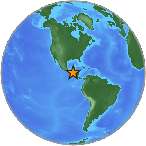
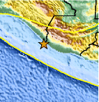
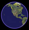
| Location | 14.443°N, 92.423°W |
| Depth | 24 km (14.9 miles) set by location program |
| Region | OFFSHORE CHIAPAS, MEXICO |
| Distances | 50 km (30 miles) S of Tapachula, Chiapas, Mexico 100 km (65 miles) WSW of Quezaltenango, Guatemala 200 km (125 miles) W of GUATEMALA CITY, Guatemala 915 km (570 miles) SE of MEXICO CITY, D.F., Mexico |
| Location Uncertainty | horizontal +/- 4.2 km (2.6 miles); depth fixed by location program |
| Parameters | NST=312, Nph=312, Dmin=>999 km, Rmss=1.01 sec, Gp= 29°, M-type=regional moment magnitude (Mw), Version=A |
| Source |
|
| Event ID | us2008yfbk |
- This event has been reviewed by a seismologist.
- Did you feel it? Report shaking and damage at your location. You can also view a map displaying accumulated data from your report and others.
Earthquake Summary
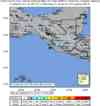
Felt Reports
Felt (III) at San Salvador, El Salvador.
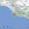
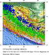
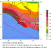
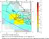
Earthquake Maps


Scientific & Technical Information

- Preliminary Earthquake Report
- U.S. Geological Survey, National Earthquake Information Center:
World Data Center for Seismology, Denver
