
 Feeds & Data
Magnitude 6.6 - KYRGYZSTAN
2008 October 05 15:52:49 UTC
Earthquake Details
| Magnitude | 6.6 |
|---|---|
| Date-Time |
|
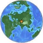
| Location | 39.515°N, 73.768°E |
| Depth | 27.6 km (17.2 miles) set by location program |
| Region | KYRGYZSTAN |
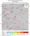
| Distances | 50 km (30 miles) NNE of Karakul, Tajikistan 60 km (35 miles) ESE of Sary-Tash, Kyrgyzstan 150 km (90 miles) SE of Osh, Kyrgyzstan 440 km (275 miles) ENE of DUSHANBE, Tajikistan |
| Location Uncertainty | horizontal +/- 3.5 km (2.2 miles); depth fixed by location program |
| Parameters | NST=299, Nph=299, Dmin=290.9 km, Rmss=0.86 sec, Gp= 22°, M-type=regional moment magnitude (Mw), Version=V |
| Source |
|
| Event ID | us2008xuay |
- This event has been reviewed by a seismologist.
- Did you feel it? Report shaking and damage at your location. You can also view a map displaying accumulated data from your report and others.
Earthquake Summary

Felt Reports
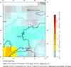
At least 74 people killed, 140 injured and dozens of buildings destroyed at Nura. Some buildings damaged in Wuqia Xian, China. Felt (IV) at Dushanbe, Tajikistan. Felt (IV) at Taraz and (III) at Almaty, Kazakhstan. Felt (II) at Bishkek, Kyrgyzstan. Felt at Kashi, China; Islamabad, Pakistan; Gharm and Khorugh, Tajikistan; Toshkent, Uzbekistan.
Tectonic Summary
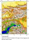
The earthquake of October 5, 2008, occurred as a result of reverse faulting in the region of the Tien Shan and Pamir Mountains, near the intersection of the borders of Kyrgyzstan, Tajikstan, and China. The thrust nature of faulting is inferred from the characteristics of seismic waves radiated by the earthquake source. The faulting that caused the earthquake is a consequence of north-northwest, south-southeast, oriented compressive stress that ultimately arises from the motion of the India plate northwards with respect to the Eurasia plate at a rate of over 40 mm/yr. At the longitude of the earthquake epicenter, the principal boundary between these plates is situated in northern India and Pakistan, approximately 600 km south of the epicenter, but the zone of tectonic deformation associated with their convergence extends to the north of the principal boundary for more than 1000 km.
The tectonics of the epicentral region are complex, and both strike-slip and reverse faulting earthquakes have occurred in the vicinity of the October 5 shock. A magnitude 7.1 earthquake occurred on August 11, 1974, within several tens of kilometers of the 2008 shock; its aftershock sequence included earthquakes generated by both strike-slip and reverse faulting.
Earthquake Maps


Scientific & Technical Information

- Preliminary Earthquake Report
- U.S. Geological Survey, National Earthquake Information Center:
World Data Center for Seismology, Denver
