
 Feeds & Data
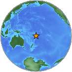
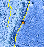
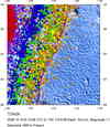
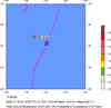
Magnitude 6.9 - TONGA
2008 October 19 05:10:33 UTC
Earthquake Details
| Magnitude | 6.9 |
|---|---|
| Date-Time |
|
| Location | 21.864°S, 173.814°W |
| Depth | 29 km (18.0 miles) set by location program |
| Region | TONGA |
| Distances | 165 km (105 miles) ESE of NUKU'ALOFA, Tonga 355 km (220 miles) S of Neiafu, Tonga 525 km (325 miles) ESE of Ndoi Island, Fiji 1995 km (1240 miles) NE of Auckland, New Zealand |
| Location Uncertainty | horizontal +/- 4.5 km (2.8 miles); depth fixed by location program |
| Parameters | NST=353, Nph=353, Dmin=906.7 km, Rmss=0.88 sec, Gp= 29°, M-type=regional moment magnitude (Mw), Version=Q |
| Source |
|
| Event ID | us2008yiap |
- This event has been reviewed by a seismologist.
- Did you feel it? Report shaking and damage at your location. You can also view a map displaying accumulated data from your report and others.
Earthquake Summary
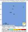
Felt Reports
Felt (IV) at Nuku'alofa and also felt at Vaini.
 Tsunami Information
- NOAA West Coast & Alaska Tsunami Warning Center
- NOAA Pacific Tsunami Warning Center
- Tsunami Information Links
The earthquake locations and magnitudes cited in these NOAA tsunami bulletins are very preliminary and may be superceded by USGS locations and magnitudes computed using more extensive data sets.
Earthquake Maps


Scientific & Technical Information

Additional Information, News Reports
- Preliminary Earthquake Report
- U.S. Geological Survey, National Earthquake Information Center:
World Data Center for Seismology, Denver
