 |
 | |
  | |
|
|
|
|
Mount Rainier National Park
Plan Your Visit
|
|
|
|
|
| |
 |

|
| NPS Photos |
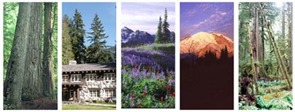
| Five scenes of Mount Rainier National Park (left to right): old growth forest, a building in the historic district, a meadow in summer, the mountain at sunrise, and a temperate rainforest. |
|
|
Mount Rainier has five developed areas: Longmire, Paradise, Ohanapecosh, Sunrise, and Carbon/Mowich. Although the level of development in these areas ranges from basic -little more than a campground and picnic area- to extensive -hotel, restaurant, visitor center, campgrounds and picnic areas- each can serve as a base for exploring the rest of the park. Learn more about each of these areas:
Longmire
Paradise
Ohanapecosh
Sunrise
Carbon and Mowich
Be Prepared for the Weather
July and August are generally sunny and mild, with the chance of showers. The rest of the year is usually quite rainy, with heavy snowfall from November through April. Raingear is recommended year round. Trails are steep and well maintained in summer and snow covered and difficult to follow in winter. Check the for current conditions.
Have a Safe Trip
Mount Rainier, an active volcano, is a dynamic landscape. Review this before you visit the park and practice the safety tips while you are at Mount Rainier.
|
|  |  |
|
|
|
|
|
|
|
|
|
 |
|
Did You Know?
The 93 mile Wonderland Trail encircles the mountain offering hikers commanding views of Mount Rainier blanketed by 25 icy glaciers. The trail leads through extensive subalpine meadows of wildflowers and lowland old growth forest. The Tahoma Creek suspension bridge is part of the Wonderland Trail.
|
|
|
|
Last Updated: June 09, 2008 at 15:57 EST |


