Local weather forecast by
"City, St" or zip code |
| Search
by city or zip code. Press enter or select the go button to
submit request
|
|
|
Aviation Weather
| Welcome to the newly
redesigned Aviation Weather page. We hope this becomes a one-stop
shopping for all of your needs. |
Tactical Decision Aid
| The Terminal Aerodrome
Forecasts (TAF) is used by our partners in the aviation community
to make critical decisions across the National Air Space. The Tactical
Decision Aid (TDA) presents the TAF in an easy to read format. The
program also displays the current observations and the forecast conditions
over the next 12 hours for the specified airport. This service is
courtesy of Eric Avila at the Center
Weather Service Unit in Houston, TX. |
Click on Map Below for TAF Forecasts
Click on a red dot for the TAF at that location.
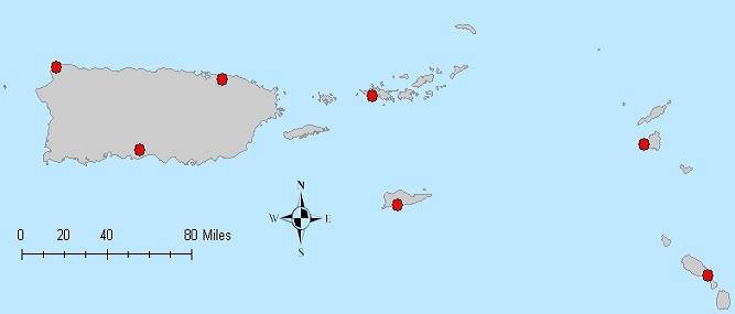
Local Surface Observations
-
San Juan, Puerto Rico (Luis Munoz Marin International Airport)
-
Roosevelt Roads/Ceiba, Puerto Rico (Former Naval Station, Ofstie Field)
-
Ponce, Puerto Rico (Mercedita Airport)
-
Aguadilla, Puerto Rico (Rafael Hernandez Airport)
-
Charlotte Amalie, St. Thomas, U.S. Virgin Islands (Cyril E. King Airport)
-
Christiansted, St. Croix, U.S. Virgin Islands (Henry E. Rohlsen Airport)
-
Beef Island, Tortola, British Virgin Islands
-
Golden Rock, St. Kitts and Nevis
-
St. Maarten, Netherlands Antilles (Juliana Airport)
Local Upper Air Observations
Local Aviation Climatology
Additional Resources
|

 National Weather Service Forecast Office