|
New Grid
Point Forecast Products Available!
 Notice
something different about our Forecasts? Notice
something different about our Forecasts?
In an exciting development, the National Weather
Service in San Juan is now offering point
forecasts, through 7 days, based upon user selectable
parameters (such as point and click and entering a latitude and longitude).
Click
here for an example forecast for San Juan, Puerto Rico.
You will notice the forecast wording is different from the
old zone based forecast text. You can still get the old
averaged forecast text by clicking on the link at the bottom
right of the page that says, "Zone Averaged Forecast for __
County, PR." Click
here for an example zone averaged forecast for San Juan, PR.
We are also offering two
more experimental products online.
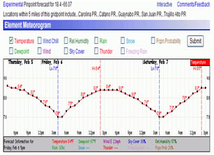
The Element
Forecast Meteorogram show various user selectable
forecast elements, on an hourly basis, based upon a gridded
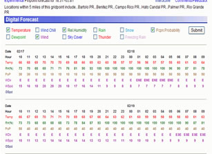
data forecast point. The Digital
Tabular Forecast is similar to the Meteorogram, but
it shows the data in a different format.
|
The Element Forecast
Meteorogram |
The Digital Tabular
Forecast |
 |
 |
Wondering how these forecasts are created? Forecasters from
your local National Weather Service Forecast Office in San Juan, Puerto Rico use what is called IFPS to create hourly forecasts of
sensible weather elements such as sky cover, temperatures, dew
point temperatures, wind speed and direction to just name a few.
The data is then used to create the forecast text and images you
see on our site. You can read more about IFPS and our National
Digital Forecast Database site by clicking here. |


