To compare current drought conditions with last week’s map, click here.
Visit the NDMC Photo Gallery to see photos of drought conditions in California, Georgia, South Carolina, and other states. If you have photos showing drought conditions, please consider submitting them to the Photo Gallery. The data cutoff for Drought Monitor maps is Tuesday at 7 a.m. Eastern Standard Time. The maps, which are based on analysis of the data, are released each Thursday at 8:30 a.m. Eastern Time. NOTE: To view regional drought conditions, click on map below. State maps can be accessed from regional maps. |
To compare current drought conditions with last week’s map, click here. |
| To view tabular statistics of this week's Drought Monitor, click here. | To view tabular statistics for the Drought Monitor archive, click here. |
| To view Drought Monitor Change Maps, click here. |
NDMC's Drought Impact Reporter |
6-week animation |
12-week animation |
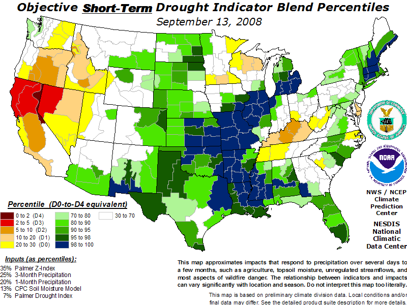
short-term drought indicator blends |
long-term drought indicator blends |
 |
 |
 |
 |
 |
| For a .pdf version of the Drought Monitor, click here. |
| For more information on the Drought Impact Reporter click here. |
| For annual animations of the Drought Monitor click here. |
| For more information on the above experimental drought blends, see http://www.cpc.ncep.noaa.gov/products/predictions/tools/edb/droughtblend-access-page.html#exp. |
| The drought indicators that are synthesized into the Drought Monitor map are on this website, under Forecasts and Current Conditions. |
| This summary map is based on a multi-index drought classification scheme. |
| For local details and impacts, please contact your State Climatologist or Regional Climate Center. |
| Free Online Sources of Historical Weather Data |
| Contact People |
| North American Drought Monitor |
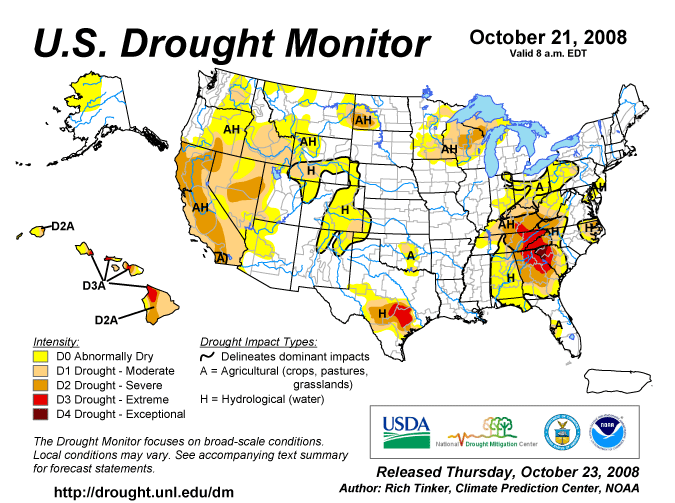
| The discussion in the Looking Ahead section is simply a description of what the official national guidance from the National Weather Service (NWS) National Centers for Environmental Prediction is depicting for current areas of dryness and drought. The NWS forecast products utilized include the HPC 5-day QPF and 5-day Mean Temperature progs, the 6-10 Day Outlooks of Temperature and Precipitation Probability, and the 8-14 Day Outlooks of Temperature and Precipitation Probability, valid as of late Wednesday afternoon of the USDM release week. The NWS forecast web page used for this section is: http://www.cpc.ncep.noaa.gov/products/forecasts/. The Southeast and East Coast: Relatively little precipitation fell on areas of dryness and drought, with totals of 0.5 to locally 2.0 inches restricted to parts of northeast Indiana, northwest Pennsylvania, western New York, and a swath from central Alabama into central and northeastern sections of the Carolinas. Most other areas received a few tenths of an inch, but little or none fell on the southern Appalachians, southern sections of Alabama and Georgia, and most of Florida. As a result, drought classifications remained unchanged in most areas. D0 was pulled from small sections of northeastern Indiana and western New York while D1 expanded through northern Kentucky and adjacent sections of Indiana and southern Ohio. Farther south, increasing short-term rainfall deficits led to D0 expansion in west-central peninsular Florida, with a small area of D1 introduced in the Tampa/St. Petersburg, FL area. The Great Lakes and Upper Midwest: A few tenths of an inch of precipitation fell on the southern and eastern reaches of the dry region, and little or none was reported elsewhere. With precipitation deficits continuing to slowly increase, D0 was expanded through north-central Michigan, D1 stretched eastward through the central Upper Peninsula of Michigan, and D2 extended to cover more of central Wisconsin. The Plains: Moderate to heavy rain locally exceeding 4 inches fell on central and eastern sections of the dry area in Texas; however, this is climatologically one of the wettest times of the year for the region, and with 30-day rainfall totals remaining below normal and precipitation shortfalls for the past year still exceeding a foot in the D2 and D3 areas, few changes were made to the Drought Monitor depiction. Some D0 was removed north of Austin, TX, but a bit of D1 and D2 expansion was introduced in some parts of southeastern Texas that missed the heavy rains. Farther north and west, isolated moderate rains were reported across central and south-central Oklahoma, but dryness persisted or intensified in most of this region, leading to some D0 expansion and the introduction of small areas of D1 in central and south-central Oklahoma. Meanwhile, moderate to heavy precipitation (up to 2 inches) prompted more D0 and D1 reductions this week in far western Oklahoma, northwesternmost Texas, and part of southwestern Kansas. Lesser amounts (generally 0.3 to 0.9 inch) kept existing dryness and drought intact across southeastern Colorado, northeastern New Mexico, and west-central Kansas while a dry week across the northern half of the High Plains likewise kept D0 to D2 conditions as they were last week from central Colorado northward through western North Dakota and eastern Montana. The West: A few tenths of an inch of precipitation fell on north-central Washington, parts of central and southeastern Idaho, western Montana, and northwestern Wyoming while little or none fell elsewhere. This precipitation pattern by itself did little to change the dryness and drought picture across the western states, but a re-assessment of precipitation deficits for the past 6 months to 2 years, in addition to reports of the degree to which this dryness is affecting streamflows and other aspects of surface moisture, led to some changes. Part of east-central California to the east of the southern Sierra Nevada was improved to D0, but deterioration was the rule in other areas of change. D0 and D1 expanded eastward in Washington while D0 was returned to southwestern Montana and expanded into northern Utah and central Arizona. Meanwhile, moderate drought replaced abnormal dryness in much of central and southern Idaho, central and northeastern Nevada, and northwestern Utah. D2 also expanded slightly to cover more of central and eastern Nevada and a small part of west-central Utah. Alaska, Hawaii, and Puerto Rico: Another dry week kept D0 conditions intact across northwestern Alaska. In Hawaii, rains of 0.5 to 2.0 inches were reported in a few locations, but most areas received only a few tenths of an inch, if any. As a result, the D0 to D3 conditions covering the state remained unchanged. Looking Ahead: During October 23 – 27, 2008, at least moderate precipitation (0.5 inch or more) is forecast for most dry areas east of the High Plains, except in Texas, Oklahoma, parts of Wisconsin and Minnesota, and northeastern North Carolina. Totals locally approaching 2 inches are expected in parts of western Pennsylvania, southwestern Virginia, and northwestern North Carolina. In contrast, little or no precipitation is anticipated from the High Plains westward to the Pacific Coast. Temperatures should average above normal from the Rockies and northern High Plains westward, especially through northern and eastern California, central and western Nevada, and southern Oregon, while cooler than normal weather settles into the southeastern quarter of the country away from Florida and the immediate Atlantic and Gulf of Mexico Coasts. For the ensuing 5 days (October 28 – November 1, 2008), the odds favor below-normal precipitation in the Southwest and across the southeastern quarter of the country. In contrast, wet weather is more likely in the northern High Plains, central and western Texas, part of northeastern New Mexico, the far eastern Great Lakes region, and portions of northwestern Alaska. Warmer than normal conditions appear favored in northwestern Alaska and through all but the northern tier of the West and High Plains while the odds tilt toward cooler than normal weather in the northern High Plains and throughout the dry areas east of the Mississippi River. |
| Dryness Categories |
| D0 ... Abnormally Dry ... used for areas showing dryness but not yet in drought, or for areas recovering from drought.
Updated October 22, 2008 |
|
|
)