HAZUS News
- Comprehensive Data Management System (CDMS) Version 2.0 is available from FEMA
- FEMA Introduces HAZUS-MH Training and Credentialing Program
- HAZUS-MH Used to Assess Flood Damage in Iowa
- Summary of HAZUS-MH Databases
- MR3 Patch 2 now available from FEMA!
- HAZUS-MH Used to Map Indiana Earthquake
- FEMA Concludes a Successful 2008 Annual HAZUS Users Conference
- Using HAZUS-MH to Promote Seismic Safety
- Updated Annualized Earthquake Loss Study (FEMA 366) Now Available
- HAZUS-MH Used in Support of Utah Seismic Safety Legislation
- HAZUS-MH Used in Two Integrated Emergency Management Courses (IEMC)
- ESRI Speaker Series Podcast Introduces HAZUS-MH Virtual Course Series
Comprehensive Data Management System (CDMS) Version 2.0 is available from FEMA
FEMA has just released the CDMS Version 2.0, a complimentary tool to HAZUS-MH MR3 that provides users with the capability to update and manage statewide datasets, which are currently used to support analysis in HAZUS-MH. CDMS greatly simplifies and streamlines the process for updating statewide datasets, and represents an important milestone in the ongoing development of the HAZUS-MH technology. CDMS replaces two HAZUS-MH tools - InCAST and the Building Inventory Tool (BIT). Read about CDMS. Download CDMS Version 2.0.
FEMA Introduces HAZUS-MH Training and Credentialing Program
FEMA is launching a new initiative that recognizes emergency managers, GISThis new initiative, which was unveiled at the 2008 Annual HAZUS-MH Users Conference, provides recognition to HAZUS-MH users who have achieved a higher level of knowledge and expertise in one or more of the models. Emergency managers and GIS
demonstrated a proficiency in the use of the model, including an understanding of the underlying data structure. The HAZUS-MH Practitioner designation is given to users of the model who have also completed courses in the use of HAZUS-MH for disaster operations, risk assessment or mitigation planning.
The HAZUS-MH training and credentialing initiative is an important development in ongoing efforts to increase technical capacity in the use of HAZUS-MH. It will enable FEMA and the states to identify and quantify the distribution of HAZUS-MH expertise across the nation, important factors in strategic planning for HAZUS-MH.
Read more about the specialized training program.
HAZUS-MH Used to Assess Flood Damage in Iowa
The value of HAZUS-MH in assessing potential flood damage was clearly demonstrated in Iowa during the recent floods. On June 9, 2008, the Johnson County Emergency Management Agency consulted with Shane Hubbard from the University of Iowa to run the model to assess the potential impacts of the approaching flood event. Of particular concern was the possible inundation of electric substations that supplies power to Iowa City. For details on the successful application of HAZUS-MH in Johnson County, download the Iowa Success Story.
Summary of HAZUS-MH Databases
One of the truly unique attributes of HAZUS-MH is the national inventory of hazard data, “point data” (e.g. essential facilities) and aggregated data on the general building stock. The Summary of HAZUS-MH Databases provides a very useful reference for these databases.
MR3 Patch 2 now available from FEMA!
Accompanying the release of CDMS is the HAZUS-MH MR3 Patch 2, which provides a range of technical fixes that are the product of extensive testing of MR3. Go to MR3 Patch 2, for a detailed description of the new enhancements.
Download HAZUS-MH MR3 Patch 2
Read HAZUS-MH MR3 Patch 2 Detailed Release Notes
Additional information on Patch 2 can be found in the FAQ section.
HAZUS-MH Used to Map Indiana Earthquake
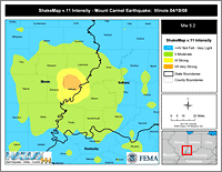
On April 18, 2008, a magnitude 5.2 earthquake occurred in the Wabash Valley Seismic Zone, centered about six miles from Mount Carmel, Illinois and about 131 miles east of St. Louis, according to the U.S. Geological Survey. The ground shaking was felt in parts of southern Illinois and Indiana, causing non-structural damage in Wabash County, Illinois and surrounding counties. View larger graphic.
A team from FEMA Region VIII conducted a HAZUS-MH run to compare observed damages and reported damages. View the HAZUS-MH findings.
FEMA Concludes a Successful 2008 Annual HAZUS Users Conference
The recently concluded 2008 Annual HAZUS-MH conference brought together a diverse audience of approximately 300 emergency managers, model developers, GIS professionals, educators and risk management specialists to share expertise and experience in the development and use of HAZUS-MH. This year’s conference coincided with the release of the Comprehensive Data Management System (CDMS), a significant
milestone in the ongoing development of HAZUS-MH.
Using HAZUS-MH to Promote Seismic Safety
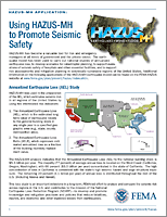
HAZUS-MH has become a valuable tool for risk and emergency managers at all levels of government and the private sector. The earthquake model has been used to carry out national studies of annualized earthquake loss, to develop scenarios for catastrophic
planning, to support evaluations of seismic safety of hospitals and other essential facilities, and to support risk assessments and mitigation planning in seismically vulnerable regions of the United States. This handout shows some of the ways HAZUS-MH has been used to
promote seismic safety. Download the Handout.
Updated Annualized Earthquake Loss Study (FEMA 366) Now Available
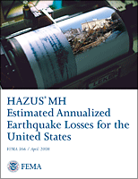
The recently updated HAZUS-MH Estimated Annualized Earthquake Losses for the United States (FEMA 366) can be downloaded from FEMA's website. HAZUS-MH was used in the preparation of the Annualized Earthquake Loss, which estimates seismic risk in all regions of the United States by using two risk indicators:
1. Annualized Earthquake Loss (AEL), which is the estimated long-term value of earthquake losses to the general building stock in any single year in a specified geographic area; and
2. Annualized Earthquake Loss Ratio (AELR), which expresses estimated annualized loss as a fraction of the building inventory replacement value.
This study is an important contribution to our understanding of the earthquake risk in the United States, and in ongoing efforts to promote seismic safety through the National Earthquake Hazards Reduction Program (NEHRP).
HAZUS-MH Used in Support of Utah Seismic Safety Legislation
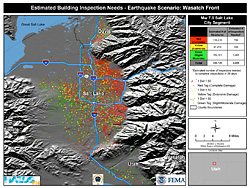
The State of Utah has recently taken important steps to reduce the vulnerability of schools to damaging earthquakes in the Wasatch Front region. House Bill 162, passed on February 21, 2008, requires a seismic evaluation of public schools, and appropriates $500,000 to support seismic safety.
HAZUS-MH has played an important role in this initiative. The model has sharpened the focus on the vulnerability of schools in this region to damaging earthquakes. Specifically, HAZUS-MH has been used to estimate losses and potential casualties from scenario earthquakes in a region that is among the most susceptible in the U.S. to seismic activity. Read the full story.
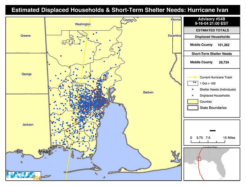
HAZUS-MH Used in Two Integrated Emergency Management Courses (IEMC)
HAZUS-MH was successfully used in two Integrated Emergency Management Courses/Hurricane Recovery and Mitigation – one that focused on South Carolina and the other on Mobile, Alabama. These courses bring together State and local officials from the “study area” to develop and implement recovery and mitigation strategies following a major disaster.For these courses, HAZUS-MH was used to develop two scenario events:
 1) Hurricane Alonzo, a Category 3 event that reached landfall southwest of Horry County in South Carolina, and 2) Hurricane Daphney, a Category 4 hurricane that followed the same track as Hurricane Ivan in 2004, impacting southern Alabama and the Florida panhandle.
View larger Estimated Peak Gusts Wind Speeds: Hurricane Alonzo map graphic (64 k).
For both exercises, HAZUS-MH depicted the hurricane paths and extent of
 wind
wind HAZUS-MH is well suited for community or state-based hurricane exercises. The loss estimates enable response and recovery officials to delineate the extent of damage, and to scale resource requirements to support recovery.
For additional information on how HAZUS-MH can be used to support response and recovery operations, contact Tom Durham at TSDurham@PBSJ.com.
ESRI Speaker Series Podcast Introduces HAZUS-MH Virtual Course Series
Listen and learn about the upcoming HAZUS-MH virtual course series developed by ESRI and Vince Brown, Senior Program Specialist in the Mitigation Division at FEMA, and Kevin Mickey, Director of Professional Education and Outreach at The Polis Center, Indiana University, Indianapolis. In the podcast, the speakers provide an overview of the courses and their objectives as well as the ideal candidates for them and how they will benefit from the training.
With seven online courses in all to serve varying interests and training needs, the series will help public and private organizations plan for and mitigate natural disasters. Courses include the following:
- HAZUS-MH for Decision Makers (Free Course)
- HAZUS-MH Overview and Installation (Free Course)
- Introduction to Using HAZUS-MH to Assess Losses from a Riverine Flood Hazard
- HAZUS-MH Flood Model Output and Applications
- Integrating User Supplied Hazard Data into the HAZUS-MH Flood Model
- Introduction to Using HAZUS-MH for Hurricane Loss Estimation
- Introduction to Using HAZUS-MH for Earthquake Loss Estimation
Read full course descriptions.
Listen/Download the HAZUS-MH Web Course Series Helps Mitigate Natural Disaster podcast. To listen to additional podcasts, visit www.esri.com/podcasts.
Download the HAZUS-MH Virtual Courses Handout with the complete course descriptions.
Download Plug-in
Some of the links on this page require a plug-in to view them. Links to the plug-ins are available below.
Last Modified: Wednesday, 20-Aug-2008 13:55:51 EDT
Fast Facts
Since the late 1990s, HAZUS has been used to support analysis of shelter requirements, displaced households, and residential losses from earthquakes, hurricane winds, and floods. This analysis has important potential applications for FEMA’s Individuals and Households Program (IHP) applications include determining the exposure of population to hazard impacts (hurricane winds, storm surge, ground shaking); and estimations such as the number of IA Preliminary Damage Assessment Teams required for a disaster, residential damage, short-term shelter requirements, or number of displaced households.
 Email Updates