Project TriNet Opens a New Era in Earthquake Monitoring
NEHRP Success Story
 "I just wanted to say thank you for having this web site. We were able to call the nearest maintenance yard, which was near Barstow. We could tell them where to go out to inspect our bridges."
-CalTrans District 8 Bridge Crew
Following the Northridge earthquake in 1994, FEMA provided funding to the California Institute of Technology, the California Division of Mines and Geology, and the USGS to upgrade earthquake monitoring in southern California. The result was project TriNet, a cooperative effort to expand and modernize earthquake monitoring in the region and to provide timely and accurate information on earthquake occurrences.
The development of TriNet, which began in 1997, included:
- Installation of 150 broad-band seismometers by 2002
- Installation of 450 strong-motion sensors by 2002
- Development of a data center to manage and process the information
- Development of new products, especially “ShakeMap“
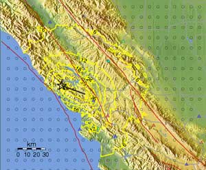
Earthquake shaking is strongly affected by the local geology and soil conditions, and the pattern of the intensity of shaking does not fall in concentric circles about the epicenter. With data from new seismometers available in “real-time,“ TriNet seismologists realized they could produce realistic contour maps showing the severity and distribution of ground shaking within minutes of an earthquake. This product, called “ShakeMap,“ was made available at TriNet web sites and has proven immensely useful to emergency management officials and managers of infrastructure and lifeline systems. Now, whenever an earthquake occurs in southern California, there is a regional map available on the web that shows the shaking pattern.
Project TriNet proved so successful that the USGS used it as the pilot model for the Advanced National Seismic System (ANSS). ANSS is an initiative to expand TriNet capabilities to other urban centers in areas of high to moderate seismic risk. Through ANSS, the USGS and regional partners have begun to develop TriNet-like capabilities in the San Francisco Bay region, the Puget Sound region, Salt Lake City, Reno, Anchorage, and the Memphis and St. Louis areas. In addition to providing ground shaking information for emergency response, the engineering community can apply ANSS data in the design and construction of earthquake resistant buildings and critical facilities.
Last Modified: Friday, 19-Oct-2007 09:42:43 EDT
 Email Updates