NVHUG - Loss-Estimation Modeling
of Earthquake Scenarios
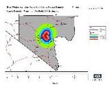
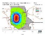
The State of Nevada - With the support of the Nevada Division of Emergency Management the Nevada Bureau of Mines and Geology (NBMG) conducted a project to model the potential earthquake loss in each county in the state of Nevada using HAZUS-MH. Potential earthquake faults that are located near each County seat where selected as the basis for each County HAZUS-MH model.
One of the first pieces of information needed in disaster planning, preparedness, and response is a general estimate of potential damage and costs of an event, such as an earthquake. Nevada has a relatively high level of earthquake hazard, but that hazard is not evenly distributed throughout the state.
Another relevant factor is that the characteristics of the population, infrastructure, and societal resources vary dramatically across the state. The probability of at least one magnitude 6 or greater event in the next fifty years is between 34 and 98%. The probability of at least one magnitude 7 or greater event in the next fifty years is between 4 and 50%.
Earthquake hazards include intense ground shaking, ruptures of the ground, liquefaction, landslides, and ancillary problems, such as fires and hazardous waste spills. Understanding these facts, plus the fact that it is possible to prepare, respond, and mitigate structural and nonstructural risks motivated this project.
A fault that has been determined to be a likely source of an earthquake was selected near each County seat. How often such an earthquake may occur, a parameter that varies from thousands to tens of thousands of years, was not considered in this study. In all cases it is not known when the next earthquake will occur, only that there is a high probability of occurrence. The earthquake scenario provides decision makers with information they need to plan for an earthquake occurrence.
All county scenarios in the report were run using the WUS shallow crustal event-extensional attenuation function, an option within HAZUS-MH that is applicable in Nevada. Earthquakes considered in the study ranged in magnitude from 6.5 to 7.5, the general range of historical damaging earthquakes in Nevada.
Possible economic losses ranged from about $280,000 in Goldfield to $8.8 billion in Las Vegas. These are only crude, order-of-magnitude estimates. That is, any given number may be off by a factor of as much as 10, although HAZUS runs for real earthquakes in recent years have been within a factor of two.
Significant potential economic losses, on the order of tens of millions of dollars, are indicated for most communities in Nevada. Potential major building damage per event ranges from four buildings (in the Goldfield region) to 30,000 buildings (in the Las Vegas area). Unfortunately, an accurate inventory of building stock is not available for the Level 1 analysis and therefore statistical estimates were used.
The different levels of potential earthquake consequences require different levels and types of preparedness across the state. The HAZUS visualization makes these county seat scenarios of immediate value for the local communities and for state contingency planning.
State-wide,
Nevada
Quick Facts
Sector:
Public
Cost:
Amount Not Available
Primary Activity/Project:
HAZUS-MH
Primary Funding:
State sources