
|
||
|
|
||
| View other datasets |
|
|
| ||
 |
|||
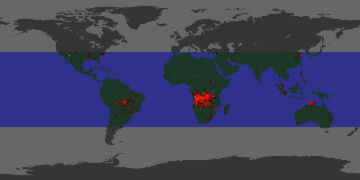
| Coverage of this dataset spans January 1998 to June 2002. | |||
The animation features of the Earth Observatory are currently unavailable. We apologize for the inconvenience. To view the full temporal span of this dataset, please view the 4km TRMM Fires monthly holdings. | |||
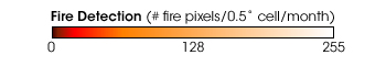 Product description: These fire data, derived from Tropical Rainfall Measuring Mission (TRMM) Visible and Infrared Scanner (VIRS) measurements, show the number of 4.4 square kilometer pixels in each half-degree grid cell (each cell is 2500 square kilometers at the equator) that are hot enough to contain a large fire. These data, summarized for each month, are currently being used to monitor natural and man-made fires in the Tropical and Sub-tropical zones (+/- 40° from the equator). Forest and savanna fires in the tropics are known to affect both regional and global climate, ecology, biodiversity, and air quality. (Courtesy L. Giglio & J. Kendall, SSAI; data from TRMM VIRS)
|
|
Subscribe to the Earth Observatory About the Earth Observatory Contact Us Privacy Policy and Important Notices Responsible NASA Official: Lorraine A. Remer Webmaster: Goran Halusa We're a part of the Science Mission Directorate |