Supplemental Application Guidance for Unguided Suborbital Launch Vehicles
Attachment 2 - Hazard areas
Draft - 08/15/98
General
- An applicant shall conduct analyses to define an impact hazard area, aircraft hazard areas, and ship hazard areas in accordance with the definitions, input, methodology, and output prescribed below. An applicant may also be required to conduct a collision avoidance analysis (COLA).
- Hazard areas are created by nominal events when conducting launch operations. Access to hazard areas shall be controlled and public safety status may require monitoring. This is typically accomplished by controlling access to the area, and real-time surveillance of the area just prior to launch. The impact hazard area may not contain population, including permanent and transient population.
Input Requirements
The following inputs are required to determine the hazard areas below:
- Vehicle dispersion. The range and cross range impact dispersion information from Attachment 1.
- Trajectory impact data: Latitude and longitude of each launch vehicle stage or ejected component nominal impact point from Attachment 1.
Methodology
- Maximum Impact Range and Impact Hazard Area:
- Maximum impact range area. An applicant shall define a maximum impact range area by computing the launch vehicle's maximum range trajectory as defined in Attachment 1.
- Impact hazard area. An applicant shall determine the impact hazard area as depicted in Figure 2-1. The impact hazard area is composed of two circles and straight lines connecting the circles at tangent points to the circles. The first circle, with origin at the launch vehicle's launch point, has a radius of 1 nautical mile. The second circle, with an origin at the nominal no wind impact point for the final launch vehicle stage, has a radius of 3 sigma as defined in Attachment 1. No populated areas are allowed inside the impact hazard area.
- Intermediate stages. After wind weighting on launch day, an applicant shall verify that the wind drifted impacts of intermediate stages and their 3-sigma dispersion areas are within the impact hazard area cone.

Figure 2-1. Impact Hazard Area (enlarge)
- Aircraft Hazard Area:
- An applicant shall compute an aircraft hazard area for each impacting launch vehicle stage or component. The aircraft hazard area shall be clear of all aircraft from launch to impact of all stages.
- The aircraft hazard area shall be a three dimensional space from 60,000 feet to the ground, and shall encompass the 3 sigma dispersion area of each impacting launch vehicle stage or component from 60,000 feet until impact. A buffer shall be added to account for aircraft travel during launch vehicle flight to impact. The buffer shall be a minimum of aircraft speed (assume 700 miles per hour) times the launch vehicle's flight time to impact.
- An applicant shall establish procedures with the nearest Air Route Traffic Control Center for the issuance of a Notice to Airmen (NOTAM) prior to a launch, for the closing of air routes during the launch window, and other such measures as the Air Route Traffic Control Center deems necessary to protect public health and safety.
- Real time coordination with the appropriate FAA center shall be made to receive a predicted verification that the hazard area is clear of all aircraft at the launch time.
- Ship Hazard Area:
- An applicant shall compute ship contour ellipses, with the same semi-major and semi-minor axis ratio as the launch vehicle impact dispersion, in which the hit probability of 1, 2, 5, 10, or 20 ship(s), located at the edge of the ellipse, is equal to 1x10⁻⁵. See Figure 2-2. The size of ships will be assumed to be 120,000 square feet, unless information is available to reduce the ship size. Applicant shall establish ship contour ellipses for all launch vehicle stage or component impact areas.
- To compute ship hit probability, an applicant shall compute the distance from the nominal impact point at which the impact probability is 1 x 10 -5. See Figure 2-3.

Figure 2-3
Psi = Px · Py
where:- X1, X2, Y1, & Y2 are distances from the impact point to the ship
- x = 1 sigma dispersion value in X direction
- y = 1 sigma dispersion value in Y direction
- Px = probability of hitting a ship in the X direction
- Py = probability of hitting a ship in a Y direction
- Psi = probability of individual ship hit
- Ps = Total probability of hitting ships
- Place the ship at a constant range and cross range sigma distance and through an iterative process, increase the range until the ship hit probability equals 1 x 10⁻⁵ for the number of ships being calculated. This process shall be repeated for each ship contour line.
- An applicant shall complete an agreement with the local U.S. Coast Guard district to establish procedures for the issuance of a Notice to Mariners prior to a launch and other such measures as the Coast Guard deems necessary to protect public health and safety.
- Unless an applicant can demonstrate that the ship density in a particular region is low enough to assure that the number of ships located inside the ship contour ellipses are less than the maximum ship limit for each contour, during prelaunch operations, the applicant shall monitor ship locations to assure that the number of ships located inside the ship contour ellipses are less than the maximum ship limit for each contour.
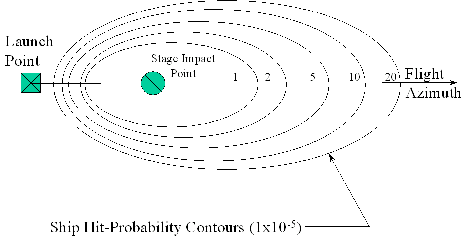
Figure 2-2. Ship Impact Contours

Figure 2-3. Ship Impact Computations
- Collision Avoidance Analysis (COLA):
If the performance of the applicant's launch vehicle is sufficient to potentially endanger manned or mannable objects in earth orbit, the FAA will work with the applicant to conduct a collision avoidance analysis (COLA).
Output
For each of the analyses defined above, the applicant shall document the methodology used, the source of input data, and a sample calculation. The resulting hazard areas shall also be documented. Each hazard area shall be presented graphically displaying the centroid of ellipses and lengths of semi-major and semi-minor axes. The presentation of the maximum impact range area and impact hazard area shall include geographical features such as buildings, cities/towns, roads, etc.