
|
||
|
|
||
| View other datasets |
|
|
| ||
 |
|||
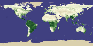
| Coverage of this dataset spans January 1982 to December 1998. | |||
The animation features of the Earth Observatory are currently unavailable. We apologize for the inconvenience. To view the full temporal span of this dataset, please view the Vegetation/NDVI monthly holdings. | |||
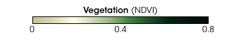 Product description: To measure and map the density of green vegetation across the Earth's landscapes, scientists use satellite sensors that observe the distinct wavelengths of visible and near-infrared sunlight that is absorbed and reflected by the plants. Calculating the ratio of the visible and near-infrared light reflected back up to the sensor yields a number from minus one (-1) to plus one (+1). The result of this calculation is called the Normalized Difference Vegetation Index, or NDVI. An NDVI value of zero means no green vegetation and close to +1 (0.8 - 0.9) indicates the highest possible density of green leaves. Scientists now have a modified green vegetation data set called FASIR NDVI. In short, FASIR NDVI is a highly corrected global data set composited into one-month time periods. Scientists removed a variety of erroneous artifacts from the data, ranging from sensor degradation, to volcanic aerosol effects, cloud contamination, short-term atmospheric effects (e.g., water vapor and aerosol effects), sun angle variations, and missing data. These data were collected from January 1982 through December 1990 by the Advanced Very High Resolution Radiometer (AVHRR) flying aboard NOAA-7, NOAA-9, and NOAA-11 satellites. ("FASIR" stands for Fourier-Adjusted, Solar-zenith-angle corrected, Interpolated, Reconstructed data.)
|
|
Subscribe to the Earth Observatory About the Earth Observatory Contact Us Privacy Policy and Important Notices Responsible NASA Official: Lorraine A. Remer Webmaster: Goran Halusa We're a part of the Science Mission Directorate |